Sunday, August 27, 2023

My Travel Companions: Joy and Peace

On our last full day in Twin Falls, Idaho, we drove into the canyon I. B. Perrine called Magic Valley. Initially, it was a lush agricultural area transformed by water from the Snake River. In time, however, agriculture moved out of the canyon, and placer gold miners moved in to collect the gold dust in the river sediment. But when these claims became unprofitable, the hospitality and tourist industry moved in. Today, the Magic Valley contains a  golf course, a park with hiking trails, and numerous waterfalls. This picture looks back up the canyon toward Twin Falls. The valley floor is strewn with basalt boulders, washed down by the flooding from Lake Bonneville (and others, as you will discover further on) that created the canyon. We saw three picturesque waterfalls. You can see one of these in the canyon wall to the right. And, if your eyes are good, you will see the Perrine Bridge over the canyon on the horizon to the left. This beautiful walk gave us a fantastic way to remember and celebrate an excellent week in historical, geologically significant, and beautiful Twin Falls, Idaho.


We woke early and washed Koko and Nakai before our long drive through an exciting area. Before the drive, I had already read about the flooding from ancient Lake Bonneville. But along the way, I noticed that our elevation would move from 4,200 feet to 5,200 feet. We also noted odd plateaus and shelves all along the road. I wondered if these were levels of ancient Lake Bonneville. A roadside geological information sign confirmed that it was. I spent most of the drive looking at the surrounding mountains for evidence of these ancient shorelines. The rain moved in as we approached the Salt Lake City Metro area, and my attention was riveted on the road and traffic around us. We finally pulled into our base for the next two weeks at Springville / Provo KOA in Springville, UT. I was exhausted from the drive and rested before we took on Provo and the Great Salt Lake.


After a day of chillin’ and chores, we explored Antelope Island State Park on the Great Salt Lake, formerly Lake Bonneville, Lake Provo, etc. I learned in Twin Falls that the Snake River Canyon was shaped when Lake Bonneville overflowed into Idaho’s Red Rock Canyon 12,000 years ago. I have learned that this was just the first of a series of flood events from the Great Basin in the middle of the continent. These flows are named Lake Bonneville, the first; Lake Provo, the second; and others. Each subsequent flood was a little lower as the water cut its way through the walls of Red Rock Canyon. These successive floods left a layered look, like shelves on the mountains that lined the shores of the lake. This picture shows the Lake Provo Shoreline sloping to the ancient Lake Bonneville shoreline. Each mountain in the area has gently sloping sides that lead up to a last tier at roughly 400 feet above the present-day surface of the Great Salt Lake.


This was wonderful until I started doing the math and found that the numbers did not add up. The ancient records show that the lake was over 900 feet deep. 900 minus 400 left 400+ feet missing? Where did they go? They were lost when the ground sprang back up after being compressed under 900 feet of water. The ground we stand on seems far more elastic than I ever imagined. The land would rebound like a very slow trampoline when the water drained and/or evaporated away. As the lake returned with accumulating rainwater, the ground would sink. The water would rise and overtop the Red Rock Canyon. The rush of water would cut a bit deeper into the canyon downriver, and the land would rebound a bit more. This has been happening for over 12,000 years. In these years, the water has lowered the pass by 300 feet. It still stands at 4,785 feet. What will the next 5,000 years hold for the Great Salt Lake? When will the next deep lake form, pressing down the ground and overlapping the canyon again? I suspect the final chapter of the Great Salt Lake has not yet been written. By the way, the first flood event, Lake Bonneville, carried three times more water than the Amazon and lasted for hundreds of years. 


One of the facts that we all learned as school children is that fish cannot survive in the Great Salt Lake. The water is too salty to support life. I was ignorantly and innocently enjoying myself, taking pictures of birds on the lake and having a grand time. Until I looked back at this picture when I was processing the images that evening. Look in the gull’s beak; you will see that he has a FISH! And it appears that he has just taken it out from under the watchful eye of the young white Pelican. Fish in the Great Salt Lake? Impossible? Apparently not! I did some digging and discovered that fish cannot reproduce or thrive in the Great Salt Lake. Still, they can survive briefly in the smaller bays after a large inflow of fresh rainwater. This picture was taken in one of those bays. I thought I had a scientific scoop of irrefutable proof of fish in the Great Salt Lake. Instead, all I had was an exception to many things I know about life in our world.


This is an excellent example of how too little education leaves us ignorant. I remember being taught that fish cannot survive in the lake. And that is true. But that does not mean that under certain conditions, they cannot exist there. I assumed I understood things when I was ignorant of the exceptions. And until I saw evidence to the contrary that caused me to ask questions about my assumptions, I remained clueless. Everything we think we know needs to be weighed on the scale of observation. When our observations challenge our beliefs, we need to respect the observations and raise questions about our beliefs. Suppose we defer to our opinions and ignore the evidence before us. In that case, we will continue to live in willful ignorance of ourselves and the world around us. I owe a debt of gratitude to this little fish that braved the salt water and lost his life. He made me just a minuscule less ignorant. I hate to think how many other creatures will have to die before humanity finally gets a little less ignorant.


The Great Salt Lake was covered with birds. It is a premier birding location in our country. The birds flock here by the millions during migration; tens of thousands live here year-round. Most of these birds are predators and usually eat fish, frogs, and other creepy crawlies. But this lake has very few of any of these. Why do vast numbers of birds come here, and what do they eat? This question was answered at the Visitor Center. The roots of the food tree on the Great Salt Lake are in those orange, red, yellow, and green algae mats that float on and lay just below the water's surface. These algal mats are the foundation of a complex chain of life in this environment.


As I learned in the lava beds, algae are efficient little chemical manufacturing plants that convert inorganic minerals into nutrients. When they work with fungus, they form lichen that breaks down rocks and organic matter. But when they float in or under toxic water, they use the sun's energy and the minerals present to create life-giving biological compounds for themselves and others around them. Tiny, annoying bugs fly down and feed on this algae bloom. The bugs further convert the algae into more nourishing food for lizards and birds. These creatures then become food for other predators. As they die or excrete their waste, this all runs back into the lake and becomes another layer of building blocks for the chemistry of life in this harsh area. Life is utterly amazing. Given enough time, it can and will adapt to environmental changes. It all requires a little heat, a few minerals, and a lot of patience. Unfortunately, the only thing humans struggle to provide is the latter.


While on Antelope Island in the Great Salt Lake, we encountered a huge herd of American Bison. They were brought here in the early 20th Century to establish a herd to protect them from extinction. There are no natural predators on the island, and they have flourished. We encountered groups of 25 – 50 animals and many lone males wandering the flats and grasslands on the island's eastern side. These majestic creatures do, in fact, rule the land as the dominant non-human mammal on the island.


The Bison is a cultural icon for the American West. Yet, as I spent time with these beasts, they became more than icons. This cow was at the edge of the herd as they grazed their way to the freshwater hole a quarter of a mile away. She kept a close eye on Nakai, our Jeep, without showing any fear or anxiety. She was in her home. She knew she was in control and did her best to avoid confrontation with the red machine. But she was ready, if necessary, to take action to protect herself and her herd. There was no blustering or faux heroics. She stood comfortably in her long, shaggy fur and looked the Jeep straight in the headlights. I knew that I was in the presence of a magnificent beast. I could learn a great deal from her if I spent the time to understand and appreciate her presence on this island in the middle of a vast salt lake.


This ancient and rugged land has produced some of the most memorable cultures in North America. Unfortunately, we did not learn about these from Brigham Young University’s Museum of Peoples and Cultures. Mostly, what we learned at BYU was how clever the Mormons were when they came to Utah. There were references to the Fremont and Ute peoples, but only by comparing them to the later Mormons who arrived and took their traditional lands. History and science deserve better than we got at BYU, so I have done a little research.


The Fremont people lived in the Great Basin for 1,300 years from around 1 AD around the Fremont River. They were contemporary with the Ancestral Puebloan People to the South. Much debate exists about how coherent a group the Fremont may have been. They are scattered throughout the Great Basin and cluster in 11 different tribes. Each tribe shares a triangular style of pictographs that we have seen in Northern NM and Western Colorado. They lived in pit houses that they used seasonally. They grew corn for much of the year but were hunters and gatherers after the harvest and until the next crop arrived. Their pottery and basket weaving are similar in color and shape. Unfortunately, there is very little left of these people. There is also little evidence of why they disappeared around 700 AD. Some believe they dispersed to the East and South, but there is not much evidence of their presence today. Many of the later cultures would refer to them as the old ones.


The Ute, however, is still present and impacts modern times. They are the namesake for the State of Utah and hold the largest reservation in the United States just East of Salt Lake City. The Uintah and Ouray Reservation covers most of the Northeastern corner of Utah. Their hunting grounds extended into New Mexico, Oklahoma, Kanas, and Wyoming. Unlike the Fremont before them, they were primarily hunter-gatherers who traveled between their hunting grounds throughout the year, often using the same locations year after year. During their travels, they got to know and entered into trade with the Puebloans, Apache, Shoshone, and other indigenous peoples in the Western part of North America.


They lived in Colorado until the Eastern tribes moved into their land in 1300 AD. The Ute moved west into present-day Utah. They included at least 11 different tribes throughout the Central part of western North America. When the Spanish introduced the horse in the 1700s, the Ute were among the first to adopt them into their lives. They became the ultimate Plains Horseman and adept at war against their enemies who traveled by foot. They spread their influence far and wide. But they could not outfight the Europeans, who overwhelmed them with multiple waves of migration and failed treaty promises. Today, they continue to operate their extensive holdings in Eastern Utah and influence the culture of the United States. However, the legacy of these noble people, both Fremont and Ute, only exists in the public imagination. When our institutions of higher learning disrespect them and, in effect, erase them from our memory, we are all impoverished by our ignorance. Their stories deserve to be told.


On our drive around Mount Timpanogos outside of Provo, we encountered Cattle Creek. This magical little stream brought delight to my soul. An earworm immediately sang, "I’ve got joy like a river…" The sound of the water cascading over the boulders was in sync with the light dancing across the foaming ripples. Greens, whites, and every shade in between stretched from the water's edge to the water's edge. The ancient Celts revered the boundary between land and water as thin places, where the boundary between our everyday world and the world of mystery beyond our experiences is very thin. I have experienced this "thin place" at the edge of massive oceans and on the shores of land-locked lakes. But this was the first time my soul resonated with the thinness of mystery at so small a stream. The ebullience of the sights and sounds stirred my soul so profoundly. This mountain stream began high on Mount Timpanogos as a snow field gradually yielding to the Summer sun. It splashed and danced over boulders, picking up bits of rock along the way. By the time it rushed past me, it reflected this sediment and the lush greens of the forest. It celebrated its journey toward the Great Salt Lake, where it would likely leave a bit of itself before evaporating, rising again, before falling as rain or snow, perhaps on the slopes of Timpanogos. That is the way of creation. Nothing is wasted. Nothing is futile. Everything can be an occasion for joy if we gain a deeper appreciation for the thin places surrounding us and the mystery these places offer our everyday lives. May we all aspire to the joy of this mountain stream.


After we made our way through the pass on the northern slope of Mount Timpanogos, we came upon this Alpine meadow. This view looks out of the heart of the mountains that serve as a backdrop to the Great Salt Lake. Mount Timpanogos has always stirred deep passions and planted the seeds of imagination. It is a place where real peace finds its way into the soul. As I took in the 360 degrees of magic and wonder surrounding me, another earworm began singing, "There'll be Peace in the Valley." It was not until the next day, while I was reading about the mountain, that I discovered how deeply this peace runs in our lives. I read the Legend of the Sleeping Squaw on the website of The Heber Valley Visitor Center. Please follow the link to read the legend.


Peace is not about living happily ever after. That is a fairy tale used to combat or counteract the reality of life. But the Legend of the Sleeping Squaw speaks to the roots of existence, the foundations of the reality of life. Bad stuff does happen, but that does not erase the majesty of love and the sanctity of the human experience in time. The ancient Ute created and told this story so that generations of their children and grandchildren would look upon this mountain, see the vast landscape of life in these mountains, and celebrate the mystery of the "Great Spirit" that surrounds them in every moment, in times both good and ill. Legends like this one help us stay vigilant, like a bison on the edge of her herd, without anxiety but ever watchful. This is the gift of deep peace. To be able to face the tragic in life while knowing that there is far more to life, we can see, is a fruit of real peace. To be able to find grace and strength in the day-to-day journey simply by remembering a story or hearing an earworm is what real peace is all about.


“There will be peace in the valley for me, some day

There will be peace in the valley for me, oh Lord I pray

There'll be no sadness, no sorrow

Oh my Lord, no trouble, trouble I see

There will be peace in the valley for me, for me"

“There’ll Be Peace in the Valley” by Thomas A. Dorsey


We were offered the gift of a glorious sunset as we came to the end of our first week in Provo, Utah. I posted a picture of the Western Sky on Facebook. It was filled with the radiance of the dying day. But a sunset is far more than the end of a day. After shooting the west, I turned and saw the sunset on Mount Timpanogos. In the East, the setting sun foreshadowed the sun's rising in a few hours. Here, echoing with the story of the Sleeping Squaw, I found myself drawn not to the past but ahead, into the future, of a day waiting to be born. I look ahead to the dwindling days left on this trip, filled with wonder at all that awaits us as we journey South. I enjoy looking back over the last five months and marveling at all we have seen. But when I look East, where tomorrow’s sunrise awaits us, I tremble with expectation. My wanderlusting soul looks to the road ahead, filled with the magic of yesterday's encounters and fully expecting even more marvelous moments ahead as we head through Utah, Colorado, and Texas for the winter before finding ourselves on the road once more.


Come on along! May joy and peace be our constant companions in our journey!


Bob


Sunday, August 20, 2023

Remembering Well!

Remembering is an essential part of being alive! The better we are at remembering, the greater the chances we will survive and thrive. This is our refrigerator door in Koko. It is slowly being covered with magnets from our journey. When we started, we bought several souvenirs for our trips: stuffed animals, tee shirts, etc. But it was obvious that while these were fun, we would soon fill Koko with stuff. We had just been through two painful downsizings and were especially sensitive to clutter. Therefore, we started collecting magnets for the refrigerator. That was in July of 2022; our refrigerator is now over half full. What will we do with them when the Fridge is full? Likely box up them by year and start all over again! After that, they will be our kid's problem! For now, we can look at them and remember that life on the road is indeed a gift we are unwrapping one day at a time!


After leaving Idaho Falls, we stopped at a Rest Area where they had a trail for Hells Half Acre, a lava flow. This area has several lava flows formed when the thin crust split open very slowly, and the lava oozed onto the surface before cooling. This lava broke down and became the fertile, well-drained soil perfect for potatoes and other crops. This magic soil is essential to life in Central and Southern Idaho. The magic is not necessarily the lava itself. Instead, the lichen and mosses that grow on the lava make the magic. Lichen is a symbiotic relationship between a fungus and an alga that involves highly complex chemical processes, not unlike a miniature chemical plant. As they form and grow on the surface of the lava, they break down the chemistry of the rock, and the residue becomes soil. This soil is collected into low spots and joins the lava broken up by water and wind to become fertile fields for plants. The lichen comes in all shades of color and texture and creates beautiful designs on the black lava. Yep, this is magical! Life is magic, and we need to look no further than the oranges and yellows on the side of that lava flow!


After our brief stop at the lava flow, we went south and west to Twin Falls, ID. We checked in to Jerome /Twin Falls KOA and set up for a week. Our first site was a disaster. There was a significant depression in the back of the site that would make leveling Koko nearly impossible. Fortunately, the KOA manager worked with us, and we found a more suitable site. (There is a reason why I spend the extra money to stay at KOAs.) Once we were set up, we discovered that the trees overhead were filled with House Sparrows! Their cheerful songs and busy flitting through the trees made this site something special. (It took a couple of days to get used to the "birdy" aroma they provided.) Unfortunately, we are only steps from the Park Office, where ice cream is on sale all day. One of my lessons for this stay will be avoiding temptation!


This is one of our hosts at the site. This is an adult male House Sparrow in breeding colors. According to some birders, these birds can be found throughout the US and are nothing special. But these creatures are extraordinary. To start with, the colors and patterns of the Adult Male are beautiful. The rufous back and soft gray head and chest set off the patterns of brown and black on their back and wings. Their song varies from a cheerful chirp and chatter in the flocks to huskier calls when they take flight. They have adapted to nearly every human habitation in North America and eat virtually anything that presents itself. If adaptation is the key to survival, then these little birds have much to teach us about surviving in the changing world of the next 50 to 100 years. That learning begins with developing a healthy respect for who and what they are. Thank you, Mr. Sparrow, for sharing your trees this week.


Twin Falls sits on the edge of the Snake River Canyon. This canyon began when the ancient Snake River wandered through the fragmented lava flows. Meanwhile, historic Lake Bonneville was forming hundreds of miles away in the Great Basin. This historic lake, remnants of which include the Great Salt Lake, began when the fully enclosed Great Basin was filled from millennia of accumulated rains. Unlike the glacial origins of the Columbia Gorge, the Snake River Canyon was enlarged by a historic flood from this huge lake when it overflowed 18,000 years ago. The ensuing yearlong flood drained through the Snake River basin, making the Snake River Canyon broader and deeper. The ebb and flow of the lake over the next 3,000 years led to the further formation of the canyon.


Today, the canyon is 50 miles long, up to 500 feet deep, and a quarter of a mile wide. The Perrine Bridge crosses the canyon at Twin Falls. Evel Knievel, an Idaho Resident, attempted to jump the canyon on his motorcycle in 1974 only to have his parachute open prematurely, thwarting his stunt. You can see the ramp he built for the stunt on the canyon's edge in the background. A later daredevil completed the jump in 2016. But this canyon is more than a site for stunts. It includes numerous waterfalls, most of which have been drowned by hydroelectric dams. The visionary I. B. Perrine started the area's agricultural development when he planted crops in the canyon. He named it the Magic Valley because of its productivity. While the agricultural value of the canyon has lessened with increased use of irrigation above the canyon, it remains a popular tourist site, including being world famous for BASE Jumping.


This is a picture of a double BASE Jump from the 486-foot-high I. B. Perrine Bridge at Twin Falls. BASE jumping stands for Building, Antenna, Span, and Earth. This bridge is the only human-made structure in the United States that allows BASE jumping year-round without a permit. It draws jumpers from all over the world, and people jump off the bridge nearly every day of the year. (That is a sentence you do not read very often.) Local instructors help you suit up and jump! (Yes, people pay big money to do this!) We watched four people jump. Marlene did a video of one of the jumps that you can see on her FB page. After jumping, the drag shoot pulls the main chute from the backpack, and the jumper gently floats down over the river onto a landing strip on the bank. It looked like a peaceful ride from our spot along the canyon rim. But I can only imagine the adrenaline rush these jumpers must have felt. (Or maybe I can't imagine that?) It was a thrill to see them, and that was enough thrill for me.


As you likely know, we enjoy visiting county museums early in our stay in a new place. These museums offer a good overview of the area and often include interesting tidbits of local lore. The Twin Falls County Museum was no exception. Among the exhibits was this poster from the early 20th Century advertising the Annual Rabbit Drive. Many homesteaders in 1904 were weary of battling the booming jackrabbit population, primarily due to the plentiful food offered by their crops. They started an annual Rabbit Drive. All available men, women, and children would gather to drive the rabbits into an enclosure. Once inside, the people would enter the pen with clubs and dispatch the critters as quickly and humanely as possible. It was a necessary, if brutal, method for protecting their crops. The drives kept the rabbit population down, but the rabbits remained prolific. (I imagine those kids grew tired of Rabbit Stew over the next week or so.) These drives were still held up into the 1930s until the dustbowl wiped out many of the homesteads. They were resumed in the 1940s but quickly faded as people's sensibilities about bunnies grew. I do not judge these folks for doing what they needed to do to survive. But it reminds us of the struggle these people faced in putting food on the table.


Next to the old schoolhouse that housed the primary collection was a barn filled with stuff that did not fit in the main rooms. Among the items in the collection was a blue Phone Booth with a phone, a B&W Television set, and this. Seriously, a microwave? History moves on, and those who remember not having a television or microwave feel the jolt! For me, history is not about the past. It is about our present way of seeing who we are as a culture. History offers insight into the things and ideas that have shaped our lives. The ice wagon across the aisle reminds us that we seek comfortable, safe lives. Ice boxes helped us enjoy unspoiled food. The telephone reminds us of how important it is to stay connected to one another, even if life carries us far away. The television speaks to our need to extend our senses beyond our immediate time and place. The microwave? I am still unsure exactly what this means, other than indulging our whims and need for an easier way to pop popcorn for our snack during the baseball game. Why do I love history? Because, when done well, it offers us a window into the soul of our life together on this planet. We all need to clean that windowpane regularly. This is best done by honest, humble remembering. Good museums help us remember who we are, lest we forget and wander into fantasy and propaganda.


As I mentioned before, Southern Idaho is covered with lava flows. These were not the result of violent volcanos or earthquakes. Instead, the lava would push up through the thin crust in the area and vent out on the surface. As the surface hardened, the lava would flow beneath the new crust, forming lava tubes until the flow gradually diminished. There are hundreds of miles of these tubes throughout the area. Many of these tubes have collapsed, forming valleys in the crust. Others would pool and collapse, forming deep depressions. But others would remain as empty tubes crisscrossing the field.


We had the opportunity to go into one of these tubes at Mammoth Cave of Idaho, outside Shoshone. This "cave" was a round tube through the lava. It was not lit, so we were given a LED lamp and set off along the path. Above ground, it was nearly 100, but it was a comfortable 41 degrees underground. These are not limestone caves with huge stalactites and stalagmites. Instead, the rock in the walls and ceiling reflected the multicolored minerals that made up the lava. Also, the intense heat of the lava vaporized many of the minerals and left a sparkling coating on the upper walls and ceiling. The picture shows some of the artistry in the stone. I have been through many caves, but this was the most fun. My camera and I painted the walls with light, and I clicked away, capturing shadows and rainbows of color frozen in the rock. I could have spent all day just taking pictures in that magical hole in the ground.


After lunch in Shoshone, we went to another lava tube called Shoshone Ice Caves. These are lava tubes but with a significant difference. Because of how the air circulates through the tube, the compression and decompression of the air create very cold conditions at 100 feet below the surface. It is cold enough to freeze the water dripping through the lava above. The bottom of the tube has 5-10 feet of solid ice beneath the catwalk. When the water drips on bare rock, it forms ice stalagmites, as pictured above. These formations were highlighted by artificial lighting throughout the cave. Frankly, the novelty was most of the experience. But it would have been great fun to have turned out the lights and used handheld lighting to see what we could see beyond the “tourist” lighting in the “cave.”


A young man from one of the ranches found this tube while searching for some lost sheep. He stuck his head in a hole and saw ice underground. He returned and told his family, who did not believe him, until they stuck their heads down the same hole. When word got out, people in town collected the ice for their beer. Soon, a businessman calculated the profits of expanding the hole. Unfortunately, between harvesting the ice and the increased air circulation from the bigger entrance, the ice-making stopped, and it became a mere hole in the ground. For several decades, the town used it as a dump. In 1962, the new landowners closed the enlarged entrance and tried different air flow techniques. They restored the ice caves. It has been a tourist attraction ever since. Once again, history has much to teach us about our future if we preserve the memories and learn from our mistakes.


These are the remnants of Shoshone Falls, once known as the Niagara of the West. But, alas, it is a Niagara no more! Old photos show the Falls extending across the exposed, lighter-colored rock. I can only imagine what this place must have felt like back then. But, like the no-longer Twin Falls site downriver, the industrialists decided they needed electricity more than a Niagara of the West. They built the dam in the upper part of the picture and started the generators. They also started selling the water to the farmers who expanded their fields beyond the Magic Valley. The rechanneled and reduced flow of the Snake River left falls with less than a third of what it had been. While this is still a beautiful sight, I lament the impoverishment of the spirit that these dams represent. In many places throughout the Pacific Northwest and Southwest, they are removing these dams and restoring the flow of these rivers. In every case, the bounty from the removal far exceeds the loss of electricity to the cities. Until we learn to take the cost of these dammed projects to the human soul, we shall continue to lead lives impoverished by our abundance.


We spent four hours at the Minidoka Relocation Center, more accurately called the Japanese American Concentration Camp, near Hunt, Idaho. This National Historic Site remembers the 13,000 American Citizens and legal residents imprisoned here during WWII for the crime of being of Japanese heritage. The exhibits told the tragic history of the place and recalled the painful scars it left on our American family. I encourage you to go there and let the people who survived life in the camp tell their stories. They are far more eloquent than I and deserve to be heard.


I found the remarkable resilience in their words very powerful. In the middle of the campground, the curators recreated this ball field. It was one of 13 in the encampment, built by the inmates to provide a semblance of life. One of these people's values was "Shikata ga nai," meaning "it cannot be helped." Some people called this resignation. But this is so much more than resignation to evil. It is evidence of the resilience of the human spirit to do the best they can until they regain control over their circumstances. The ball fields, sharing skills at building tables and chairs for one another, putting up makeshift privacy curtains in bathrooms and showers, and any number of shared activities made life bearable for themselves and their neighbors. The humanity of the inmates stands in stark contrast to the inhumanity and greed of their captors, the rest of the American people. Those first- and second-generation Japanese left that place and built or rebuilt their lives with little to no help from the rest of us. But they did not allow bitterness or anger to define them. They got on with their lives and proved themselves true heirs to the Spirit of 1776. In them, I find great hope for our nation. Our survival will depend, in part, on how well we allow them to teach us the meaning of being an American!


This is a screenshot from my phone of the intensity and track for Hurricane Hilary as it appeared on Saturday afternoon. It shows that it will be in central Nevada in the next couple of days with winds of 25+ miles per hour. It does not show the predicted 60 miles per hour gusts and the 4-6 inches of rain likely to fall on the desert. A bit of historical perspective; very few people are alive who remember when this happened the last time, 84 years ago. We planned on leaving on Monday for central Nevada but have made new plans. We will spend an extra night here in Twin Falls and allow the storm to move on.


The primary rule for our travels has always been “Safety first!” This is one of those times when the rule should serve us well. Motorhomes do not handle winds much above 25 MPH, especially crosswinds. Also, the flooding caused by that much rain in so short a time will cause closures and dangerous water hazards. Fortunately, we secured another night in our present park, where we are farther north, and the winds will be significantly diminished. We are on relatively high ground and sheltered among the trees, so we should be safe from the wind, rain, and whatever else nature may throw at us. We are doing our best, “Shikata ga nai,” given that it cannot be helped.


We have seen our share of hurricanes and tropical storms along the Texas Gulf Coast. I know that Hilary may veer off in the hours before landfall and fall apart before it reaches land. But, just like the 10-hour drive to San Antonio from Houston before Hurricane Rita, it is best to accept the situation and do what we can to be safe. As of Sunday morning, Hilary is holding her course toward a direct hit on Southern California and Southern Nevada. That calls for “Shikata ga nai.”


We have cut Nevada and Death Valley stops from our trip and will head to Utah, spending two weeks in Provo. Not sure what we will do, but that is how we wander. We will resume our planned itinerary in Southern Utah. Regardless, I am looking forward to cooler temps after the storm passes. We may even get to see the desert bloom from all the rain. Anticipation, not disappointment, marks my mood. Such is life on the open road. Such is the resilient life that is informed by well-practiced remembering.


I will close this week with a quote from the Herrett Center on the College of Southern Idaho campus. It is by Guy Gavriel Kay, a Canadian fantasy fiction writer.


“There are no wrong turnings. Only paths we had not known we were meant to walk.”


I am glad you are on this road with us, wrong turnings and all. Be sure and check our Facebook pages for daily updates.


May the road rise to meet you, my friends!


Bob


Sunday, August 13, 2023

Life Happens!

One of the biggest things I am learning about life on the road is that it is similar to life in our apartment or house. The weather dictates much of our activity. Routine life stuff happens. And then there is the not-so-routine life stuff. The benefits of changing scenery and exploring new places are part of the road. Still, the added chores of driving days and managing Koko are also part of our new lives. But all in all, life as full-time RVers is not all that different from settled city folk. This has been a full week of living for our wandering souls.

The night before we move is generally a time to reflect on and celebrate our time in a particular place. Our last night in Butte, Montana, was no exception. The rain showed up as the day ended, but Butte still gave us a sunset picture. This summed up our stay in this historic city with its complicated past. There is so much to dislike about Butte's past. The unrelenting greed at the expense of human life, the racism that stood between people who needed each other, and the wanton disregard for the needs of the land speaks to the worst of the human footprint on creation. But all this makes the brilliant sunset on our time in Butte all the more beautiful. The town has thrived! They survived the withdrawal of the Robber Baron's investments. They rediscovered a new life relying on one another instead of New York City investors. We met a football coach who is a proud son of this old town and gives tours all Summer to share that pride. He did more than tolerate Diversity; he celebrated it! Then there is a beautiful nature park built around a creek that carries the cleaned water from the perpetually acidic and polluted Berkeley Pit in the old mine.


As our time came to an end in Butte, I felt hope! As I said in my blog last week, the darkness will end, and a new light will dawn. That Sun creeping out from under the day's gloom foreshadowed the dawn of a glorious new day. The Sun is shining brightly in the 21st Century Butte. Thank you, Butte, Montana!


We loaded up and set out for our next stop on our way South. We drove through Southern Montana and crossed into Central Idaho. The drive included some beautiful landscape along a couple of rivers as we climbed a pass and descended into a broad agricultural landscape west of the Tetons. The air was clear of smoke, and the Sun created a mosaic of light and shadow on the rolling hills. We arrived at The Snake River RV Park in Idaho Falls, Idaho, around 3:00 PM and settled in for the week. This is an older Park that was built as a KOA. It is less spiffy than some we have enjoyed in the last month. But the staff was friendly, and the narrow site will provide all we need. We reviewed the possibilities for the week and found a few that we had overlooked previously. I was excited by the opportunities that Idaho Falls held for us in the week ahead.


Marlene added Idaho to our camping map next to the door on Koko. This map represents the states where we have camped since we started RVing in 2016. We only count those where we have parked a trailer or motorhome, not simply driven through. We hope to completely fill in the map when we park Koko for good. See that big hole in the middle of the map? Our original plan of filling in the rest in 2024 has been changed. We want to spend more time with our Seattle Grands next year. Therefore, if circumstances allow, we will take our shot at the Midwest in 2025. This map reminds us that we have many miles to travel before we are done!


Life on the road is all about adapting to change. This has been my photographic partner since 12/6/2015 when I took a picture of an Egyptian Goose walking along a river bank. The Canon 70D was my third digital camera and my fourth camera since my friend, Jim Britch, infected me with the Shutterbug back in 2000. My first step into digital photography happened when we returned from the Grand Canyon with 43 rolls of slides needing to be developed. This convinced Marlene that a digital camera made more sense. I bought a Canon 20D in 2005 and spent the next 4 years shooting 41,000 pictures before technological advances enticed me to change. In 2009 I bought my Canon 50D and took 27,000 shots over the next 6 years. In 2015 I replaced the 50D with the Canon 70D camera (pictured above) with improved focusing and higher pixel count (geek speak for better quality pictures.) I have been thrilled with this camera and bought higher quality lenses to complement the quality of the camera. But over the years, technology has moved on. Pixel count is no longer that important. Focusing speed and clarity have eclipsed my old 70D, and it is time to move on. My old friend has its share of bumps and scratches. The label for the programming wheel disappeared years ago. But it continues to take decent pictures, and I have resisted changing cameras for 8 ½ years after taking almost 70,000 pictures. If the next camera gives me the joy this one has offered, it will be well worth the time and expense of making the change. As I unboxed the camera, Marlene asked, "This should be the last one, right?" "Well, it should be!" I replied. I don't think she was convinced. But, then, change is always hard, especially when it involves an old friend. Hmmm…


Downtown Idaho Falls follows the Snake River. Settlement began in 1864 when Harry Rickets built a ferry across the Snake River to serve the wagon trains heading west. Matt Taylor built a toll bridge downstream of the ferry within a year, and Taylor's Crossing was born. By 1866 the community had become known as Eagle Rock due to an island in the river near the ferry where eagles nested. In time, the growing agricultural production of the area attracted the railroad, and the upper Snake River Valley saw a significant housing boom.


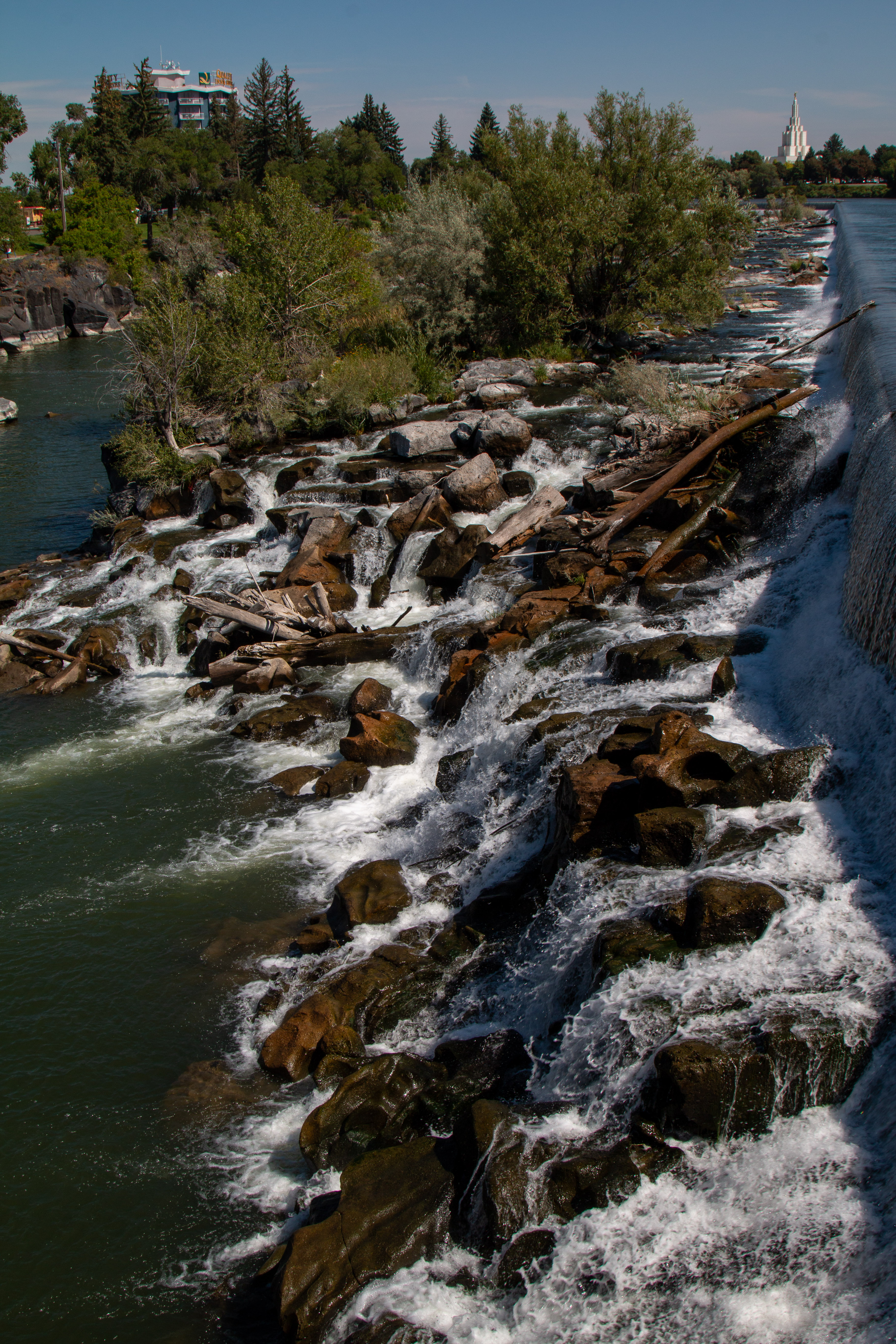
The city decided to build a small hydroelectric plant to serve the city’s growing needs. After passing a bond, the city built a canal along the river, diverting much of the water from the rapids, and opened the plant in 1912. In 1976 the upstream Teton Dam broke and destroyed the aging hydro plant. The city used this opportunity to raise the water level in the canal by 6 feet and install more efficient European turbines, making it one of the most effective hydro plants on the Snake River.


The town was renamed Idaho Falls in 1891. Today, the rapids are a ½ mile long series of falls along the raised canal that feeds the hydro plant. This is the signature feature of an old city that has successfully retooled itself for the change brought by each new century.


This stone suggests that John Coulter was in the Teton Valley in 1808. The rock is an effigy of a man and was plowed up when homesteaders were preparing their fields in the Western Foothills above the Teton Valley in 1933.


John Colter was a member of the Corps of Discovery on the Lewis and Clark expedition (1804-1806). Colter was a native Virginian but joined a trapping expedition upon discharge in St. Louis that brought him to Central Wyoming. He stayed with the Crow in Wind River and traveled with them as they sought new hunting grounds in the Teton Valley in the winter of 1807. He is said to be the first European to cross the Tetons by the South Pass. He was at the "Battle of the Flats" in Pierre's Hole (the later site of the Mountain Men's annual gathering called The Rendezvous) when the Crow defeated the Blackfeet. Colter was wounded during the battle. The following day, the Crow Council of Chiefs decided that the land was not worth the lives it would take to defend it. The Crow returned to their Wind River homeland, but John Colter chose to stay behind.


He joined the ranks of the Mountain men who trapped beaver and muskrat along the Snake and Yellowstone Rivers. He explored the basins of both rivers and was a leader in the growing fur trade. He negotiated with the tribes, sometimes successfully and other times barely escaping with the clothes on his back. One negotiation even cost him his clothes as he ran for his life. He built trading posts and helped open the area for European settlement. In 1810 he returned to St. Louis, married, and settled down. He fought in the War of 1812 as one of Nathan Boone's Rangers but died a year later in Miller's Landing, Missouri. His legacy is preserved in the many places that bear his name and the stories surrounding his travels, including the 1965 classic movie, The Naked Prey, based on his life.


We had never seen the western Slope of the Tetons in our travels. We have often seen the Eastern Slope during our trips through Teton National Park and Yellowstone. But the western Slope and the adjacent Teton Valley have their own charm. This picture is from an overlook on the edge of the Teton Valley, looking East past the foothills and into the Tetons. This is rich, agricultural land that was once the domain of the Blackfeet Indians. After the Mountain Men began returning to St Louis with stories of a broad valley beyond the mountains. Settlers began loading their wagons and heading West. Pierre’s Hole, where The Rendezvous was held, was a favorite stopover after completing the South Pass. Pierre's Hole is named for “le grand Pierre” Tivanitagon, a Hudson's Bay trapper. By 1868, 300,000 European descendants migrated to California and Oregon across the South Pass. By 1862, with the passage of the Homestead Act, many settlers made homestead claims in the Teton Valley. Their descendants still live there.


We read our way through the Teton Valley Museum in Driggs, Idaho. It is a fascinating collection that tells the story of all the people who have and still live in the valley. While it is heavy on the families whose ancestry reaches back to the 1800s, it represents the history and cultures of the area very well.


After several days of driving and exploring, we returned to the Snake River in downtown Idaho Falls. It includes the Japanese Friendship Garden. The shaded walkways and flowing water offer a respite from the heat and bustle of the river walk. In 1991, the Rotary Club of Idaho Falls began the development of a Greenbelt along the river. In 2011, the Friendship Garden was started to celebrate the 30th anniversary of the city’s association with its sister city, Tokai Mura, Japan. This stone lantern was placed near the garden. After a deadly tsunami and earthquake destroyed much of Tokai Mura, its placement was dedicated to the victims of that disaster. The Garden started to develop around the lantern and is maintained by Civic Clubs and Volunteers throughout the community. This small plot of peace is a welcome relief from the chaos that fills our lives. Thank you, Idaho Falls and Tokai Mura!


In Blackfoot, Idaho, we found the Idaho Potato Museum. If you have been following us for a while, you know we are suckers for food museums. This started with a trip to Cranberry World Headquarters in Massachusetts and has included tributes to cheese, garlic, and several other favored foods. Some are glorified gift shops, while others are genuine tributes to the food. The Potato Museum was one of the latter sharing information on the humble potato's history, production, and use. The volcanic soils of this part of Idaho are perfect for growing all potato varieties. A third of the US Russet Potato crop comes from this area. Massive fields of green potato vines with white blooms line the highways. The farms have huge cellars where the crop is stored until shipment. We read the story of how the potato went from South America to Spain, through Europe before returning to North America three hundred years ago. I discovered that most potatoes are clones growing from the tubers that are part of the stems just beneath the surface. I also learned that the tops and fruits of the potato contained deadly nightshade and were used as a poison for many years before the tubers were eaten. There is so much more to know. I will have to leave the rest to your curiosity.


This picture is of the world's largest potato crisp. It was created by Pringles to highlight their product. It is essential to distinguish the crisp from the chip. The crisp is made of mashed up, dried flakes, and a few other ingredients. While the chip is a sliced, fried potato with hundreds of ingredients in the oil and seasonings. My favorite display was a letter from the then Governor of Idaho to Vice President Dan Quayle after Quayle became the brunt of jokes for misspelling potato. The letter closes with the postscript, “By the way, Idaho does not have an e in it either.” You must love a museum that can share information and have fun. Thanks, Idaho Potato Museum, for a fun afternoon. 


When we returned from Blackfoot, I had a message that Amazon had delivered a package at the campground office. Yep, my new photo buddy had arrived. This is a Canon R6 EOS Mirrorless camera. I have spent the last 4-5 months looking at new cameras because my 70D has grown a bit “long in the lens.” Some friends allowed me to hold and play with their R6 in Gig Harbor. Since then, I have decided that this would be my choice. I was prepared to wait until the price came down when Canon released an upgrade version. Well, it happened. I could no longer resist.


This camera is mirrorless, meaning that there is no reflex mirror that must move before the shutter can take the shot. The camera is quieter, lighter, and faster to focus and shoot. All of these are important for someone who carries the camera on trails for miles at a time, shooting birds in flight and when wary critters are nearby. These and the usual technological improvements made this the perfect choice for me. With an adapter, I can use my existing lenses to save on buying new glass. All in all, this is a winner for me. Your mileage may vary!


As I said above, life on the road is not that much different from life in a house or an apartment. Life happens wherever you live. Well, life happened! I opened my MacBook to do my morning journal and noticed the computer’s Trash Bin was full. So, like any responsible person, I took out the trash. I then noticed that it started emptying hundreds of gigabytes of data. I had done some updates last week, so I figured it was just cleaning up my hard drive.


A little later, I opened the hard drive where I stored all of my edited pictures. And yep, the MacBook cleaned up that drive down to the last byte. Twenty-five+ years of photos had been deleted and erased. After figuring out the issue, I discovered that Apple had not included any way to recover them in the operating system. Disappointed? Yes. Sad? A bit. (Ok, more than a bit!) but I have been around computers for over 30 years and have learned that there are very few unsolvable problems. Most demand a little research and money. This was no exception.


Fortunately, I found an app that was able to recover my pictures. It took all day and was not cheap, but those pictures are important to me. Photography is not simply my hobby. It is a way that I exercise my mind-body-soul in the world. In taking photographs, the lens allows me to focus my attention on the world around me. In processing the pictures, I can explore possibilities and see the world more clearly. In sharing the photos, I discover kindred spirits who see the world through similar eyes and learn that others see things very differently. When I go back and look at shots I have taken, I discover undiscovered territory in my yesterdays. My photo friend freed me from the verbal trap of a lifetime of words. I discovered a new world available through the visual arts. Since I can’t draw, photography became my medium to know and experience the world. Recovering these images is tantamount to recovering my memory after losing my mind. I would have survived losing them, but I am glad I do not have to walk that path today.


As for now, all is well, and I will continue my photo journey through this adventure. I am equipped with a new buddy and the continuing support of my lifelong companion in life. Life will continue to happen, and I will do my best to keep learning and adapting.


I look forward to sharing those happenings with you as we wander down the road with my camera in hand.


Thanks for coming along!


Bob


Embracing the Possible

The Road has many lessons for the attentive traveler. This week, I am being taught the importance of embracing the possible. Unfortunately, ...