This was our last week in Utah. We had planned to spend
three weeks in the Beehive State, visiting the Golden Circle of National Parks.
But, the weather stepped in and left us with five and a half weeks to enjoy
Utah before making our way South. For our last week, we ended our stay in
Torrey before heading to Monticello for a few days. We left Utah on the 30th,
just ahead of a significant cold front sending the temps into the 30s at night.
We also left just in time to avoid the possible shutdown of the National Parks because
of the temper tantrums in DC. Overall, we are now headed South with a month of
wandering through CO, NM, and TX before ending up in Central Texas to see
family and friends. Come on along for this farewell tour of Utah.

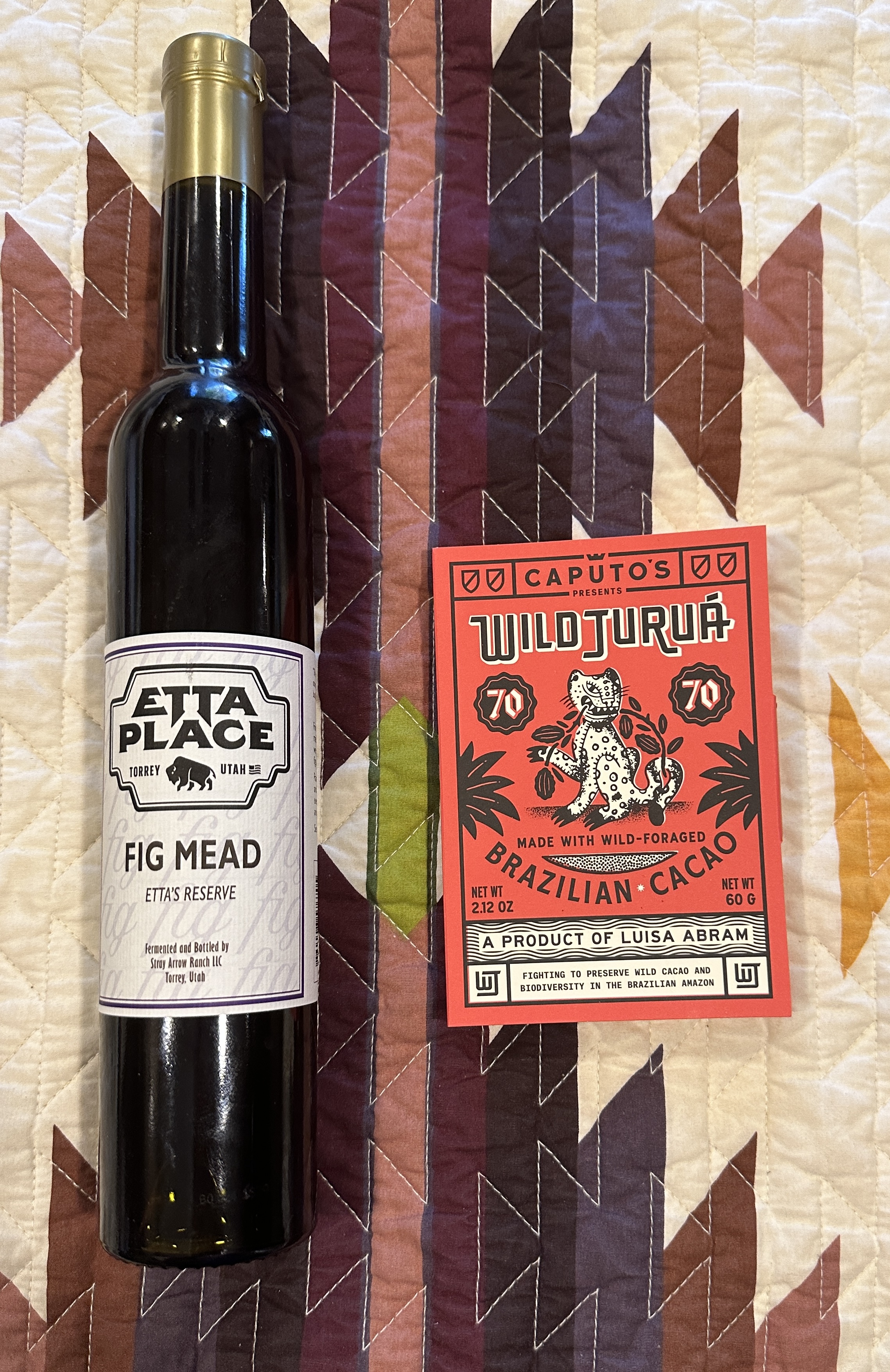
Our last full day in Torrey included a tasting at The Etta Place Cidery. We have
done wine tastings, mead tastings, and ale tastings, but this was our first
cider tasting. The Cidery is owned and operated by Ann and Robert. You can read
their story by clicking on the link above. Ann gave a wonderful tour and shared
some history behind the name. Robert is a retired Professor at UT Health
Sciences in Ophthalmology. Again, check the website for more about their
Cidery. We shared our tasting with three young women from Newfoundland. They
and our hosts made for a delightful afternoon of learning about cider and a
special mead pictured above. The chocolate was also a special treat that went
incredibly well with cider. We took a drive after a nice meal at the South
American place down the road.

Our impromptu drive on BLM land outside Torrey turned into a
lovely excursion into a beautiful canyon. Torrey is surrounded by beautiful
landscapes. The Fishlake Scenic Drive took us beneath towers, cliffs, and deep
canyons. Nakai handled it all very well.
 |
|
The seasons are starting to change at 6,000 feet at the
beginning of the drive.
|
 |
|
Deep green juniper and yellow Rabbitbrush perfectly balanced
the red rock and blue sky.
|
 |
|
Mount Boulder towers over Torrey at 11.313 feet. If you look
closely, you will see the Aspen just starting to turn Yellow.
|
 |
|
The golden light of later afternoon lights up the cliffs.
|
 |
|
Torrey sits nestled between the Fishlake Hills and the
shoulders of Mount Boulder.
|
On the road again! The following day, it was time to set off
for our next stop in Monticello, Utah. We traveled Utah 24 to 70 and then
turned South on our old favorite US 191. The landscape went from interesting to
"Wow!' We drove along deeply terraced countryside ranging from lush creek
bottoms along the Fremont to dry desert landscapes. IH 70 was nothing too
spectacular, but US 191 is one of the most interesting roads in Utah. It
traverses the vast world of Canyonlands, Arches, and Deadhorse Point before
reaching the plateau where Monticello sits, just outside of Bears Ears National
Monument and the La Sal Mountains. The drive was only three hours, but it went
by very quickly.

We arrived at The Old West RV Park in Monticello, UT. We
were here last year on our way back from North Dakota and ate at the Thai
Restaurant next door to the campground. Unfortunately, the chef is out of
commission and was closed during our stay. The RV park is a basic park that is
very clean and provides just what a short-term traveler needs. We were next to
the Hwy, but we managed for four nights.

It is no surprise to those who follow us on FB that we enjoy
eating out on the road. For me, enjoying life on the road is an exercise in
multisensory experiences, especially food! Many have asked me how I have
managed to eat well and still lose weight. Mostly, it has to do with a
straightforward formula. I can eat and drink whatever I want, but not as much
as I want! It takes self-discipline, which is much easier, with good
information from our MyNetDiary app and a willing partner in losing and
maintaining a healthy weight. You can check out the app at MyNetDiary.com. You will have to find
your own partner, however. Just remember, you can eat anything you want, but
not as much as you may want.


 |
|
What
sort of creatures can you see pictured here?
|
 |
|
Here,
we see modern and possibly ancient images sitting side by side.
|
 |
|
Snakes,
sheep, and birds appear prominently in this set.
|
 |
|
Can
you make a story out of any of these clusters of images?
|
 |
|
Do
any of these images tickle your imagination?
|
 |
|
All
the images are within 5-6 feet of the ground at the time when the artist was at
work. Some, however, are very low to the ground. What might that suggest?
|
 |
|
Some
creatures are fanciful, as if they have some mythological origin.
|
 |
|
Next
to Newspaper Rock is a small overhang that offers some shelter from the
weather. There is no evidence of how it was used.
|
 |
|
Nor
did we see any petroglyphs.
|
 |
|
This
scene is likely very similar to the view by the artists at Newspaper Rock.
Imagine living your life each Summer in a place such as this.
|
The
drive along Indian Creek from Newspaper Rock led us out of the canyon and into
the open terrain of the valley floor, which was stunning. These two buttes sit
in the middle of a wide-open space and can be seen for miles around. We drove
through a small section of Bears Ears National Monument. This Scenic Drive took
us past the Six Shooter Peaks in the photo. We soon entered Canyonlands
National Park
 |
|
These
buttes and mesas tower over the desert floor.
|
 |
|
Erosion is still taking place, and these features will, in
time, be a scattering of rocks on the desert floor.
|
 |
|
The
red Moenkopi Formation is set off by the white and gray sandstones.
|
 |
|
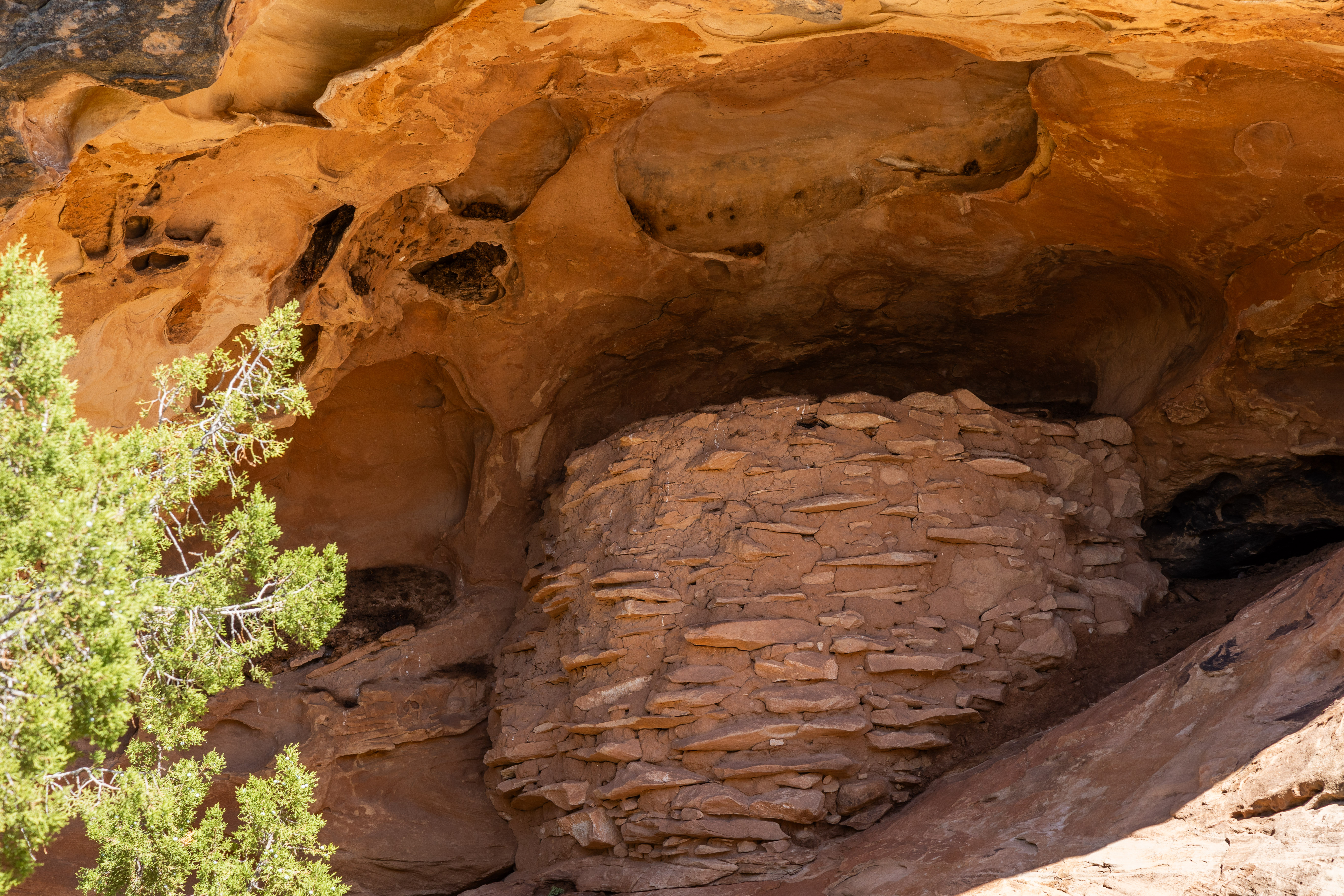
The
ancient ones lived among the rock formations. This granary was used to store
their crops from season to season. They are generally found in cliffs along
creek bottoms where water to irrigate their crops was readily available.
|
 |
|
We
have seen these through Arizona, New Mexico, and Utah.
|
 |
|
This
adorable lizard was not afraid of the giant on his doorstep. They are in charge
here and stand their ground. It looks like a long-nosed leopard lizard.
|
 |
|
Can
you find a rock in the shape of a wooden shoe in this picture?
|
 |
|
Here,
you can see evidence in the layers of the millions of years of seawater, dry land, uplifts,
and fracturing that created this magical landscape.
|
 |
|
At
Pothole Point, we found a large platform of pot-holed rock topped by huge
boulders. How this formed is bound to be fascinating.
|
 |
|
Trees
and shrubs among the boulders.
|
 |
|
This
is a rock’s impression of a Swirl Cake.
|
 |
|
How
long do you suppose that tree has been between that rock and a hard place?
|
 |
|
These
micro ecosystems provide life the shelter they need from the blistering sun and
bone-chilling winter winds.
|
 |
|
This
platform is high above the desert floor.
|
 |
|
Ancient
landscape that has not changed in centuries.
|
 |
|
This
pillar marks a beautiful overlook.
|
 |
|
It had a companion at the Confluence Trailhead.
|
 |
|
Across
the canyon sits twin pillars.
|
 |
|
In
between the rocks on top of the pillars is this old pockmarked surface from
rain and wind.
|
 |
|
It
even held a passage to the top of the rocks. No, not for me!
|
 |
|
Old
rocks and trees, what more do you need?
|
 |
|
The Needles in the distance. Sadly, no access in Nakai!
|
 |
|
The weathering creates strange shapes all around.
|
 |
|
Where
water collects, the plants thrive.
|
 |
|
Mushrooms
in the desert!
|
 |
|
An
abandoned Cowboy Camp from the days when ranchers controlled Southern Utah.
|
 |
|
Inside
an overhang that has been home to people for longer than the Cowboys.
|
 |
|
The
extended overhang allowed a lot of people to gather here.
|
 |
|
A
seep in the overhang provided water for people and the crops they likely grew
just outside it.
|
 |
Art work along the walls.
|
 |
|
The
walls are lined with seeps that help keep it cool in the blazing Summer.
|
 |
|
The
length of the main room.
|
 |
|
Just
steps outside the overhang is a lush, warm setting for living their lives.
|
 |
|
This
fern grows all along the seeps. I wonder if it is tasty.
|
 |
|
Not
a bad place to raise several generations.
|
Sand
Island is an ancient site for human habitation that reaches back to 6,500 BCE.
The site, along the San Juan River, hosts a 300-foot-long panel of Petroglyphs
that date from the earliest days of habitation. This picture shows the entire
panel. I have some detailed shots below. Like before, no one knows what they
mean or the story that they tell. But they ignite the imagination about the
people who left them for later generations to discover.
 |
|
An
impressive panel that traces the edge of the old cliff face. Does this tell a
story?
|
 |
| Another tight panel with similar markings.
Imagine how much work went into just this panel.
|
 |
|
These
faint markings may be among the original petroglyphs.
|
 |
|
These
are obvious modern markings left by people with no respect for ancient
cultures.
|
 |
|
Here,
we find Marlene's favorite image from the Anasazi, Kokopelli. He is the faint
flute player in the top portion of the panel. Someone added the flute to the
more prominent figure below the original.
|
 |
|
These figures are very intriguing. I don't know what they
are, but they appear to be quite old. This is the first time we have seen this
design.
|
 |
|
Very
faint. The cliff face has broken off in a few spots.
|
 |
|
This
looks like a story or two of successful hunts. But this is only a guess. What
do you see? Notice the figure shooting a bow and arrow at a Bighorn Sheep in
the lower center part of the panel.
|
 |
|
These
prominent figures with the three shapes above them suggest a headdress. Perhaps
this is a dancer in one of their rituals. What do you think?
|
 |
|
Among
the faintest of all the images. They are likely very, very old figures in the
Fremont people's style. The Fremont were the earliest people in the area. What
do you see?
|
 |
|
Again,
profoundly weathered and faint figures with the three tiers headdress.
|
 |
|
These
highly stylized designs are as fascinating as they are enigmatic.
|
 |
|
The
whorl is a familiar figure in many of the Petroglyph panels we have seen. There
are very few in this immense panel. What does that suggest?
|
 |
|
We
have seen these “frog figures” before at other sites. Looks like a dance move
to me.
|
 |
|
I
really want to know what this figure represents!
|
 |
|
OK,
I am almost overwhelmed!
|
 |
|
This
fellow was not talking, either. It may be a Common Lesser Earless Lizard.
|
 |
|
Then
there was this lone, little figure 100 feet away from the main panel. Why? Who
did this one? Questions abound!
|


 |
|
We
are a bit higher, and you can see a glimpse of the road below.
|
 |
|
This
view looks out on the famed Monument Valley, where hundreds of old westerns
were made, and Forrest Gump ended his cross-country running.
|
 |
|
This
was our Lunch View at Bullet Canyon.
|
 |
|
This
is the first of the Natural Bridges we saw. A Rock Bridge has a creek under it
that cuts through the fin. An Arch was cut only by wind, rain, and ice. These
are fascinating formations.
This
one is called Sipapu Bridge.
|
 |
|
Here,
you can see the creek bed under the bridge.
|
 |
|
This
is the trail to our next bridge, Kachina Bridge.
|
 |
|
I can't help myself; Dead Trees catch my eye.
|
 |
|
Kachina
Bridge
|
 |
|
The
bridge is a small part of a complex landscape.
|
 |
|
The
other end of the valley at Kachina Bridge.
|
 |
|
This
is a remarkable rock formation. What do you see besides a rock?
|
 |
|
Yep,
dead tree!
|
 |
|
The
last of the bridges we saw Owachomo Bridge.
|
 |
|
The
span is incredible. How long will it last?
|
 |
|
More
fascinating rocks
|
 |
|
Really
dead trees!
|
 |
|
Rebuilt
ruins at Mule Canyon Kiva
|
 |
|
The
rebuilt Kiva shows the ceremonial space. It was from an underground passage
from the other structures. I am not sure if it had an overhead entrance as
well.
|
 |
|
The
rebuilt base of a tower that was perhaps used to signal the next Kiva a mile
away.
|
 |
|
The
small plaza between the Kiva and the Houses.
|
 |
|
A
dying tree
|
 |
|
Butler Wash
|
 |
|
Can
you spot the ruins in the cliff face?
|
 |
|
Ruins
of structures
|
 |
|
An
old building with a wall, suggesting storage, perhaps a granary.
|
 |
|
Yep,
I see two eyes staring out of the cliff face. The left eye is blind!
|
 |
|
The
main house, including the Kiva, storage, and apartments.
|
 |
|
A
smaller building lower down and apart from the main buildings.
|
 |
|
Imagine
raising your family in this environment. These were sturdy folks.
|
Our
time in Utah came to a close. This is a shot from The Great Salt Lake, where
our long journey through Utah began. We have seen some marvelous sights and
encountered some fascinating history. We had to do a lot of filtering because
the Mormon Culture has so wholly dominated this landscape for over a hundred
years that it is hard to see past their Temples. Northern Utah was unexpected
and educational. Southern Utah was inspiring. So Long to Utah, the Great Salt
Lake, Aquarius Plateau, and the Grand Staircase.
Our drive to Durango took us along familiar roads. But we
could enjoy the first bit of color as Fall took hold of the San Juans in
Southern Colorado. Our stay here will only be 6 days, but I look forward to
some exciting adventures. We are staying in Oasis RV Park in Durango, CO, and
will head into the mountains. We are roughly a week ahead of the first real
cold snap and hope to have fantastic weather for our stay.
We have a plaque in Koko that we picked up in Bar Harbor a
couple of years ago, "Life is a journey, not a race." We are not
hurrying through our travels. We know how fortunate we are to be able to enjoy
the road together, and I want to savor every minute of it. As we head back to
Texas for the winter, I am planning our travels in 2024, but for now, I am
taking my time. In the coming months, we will be seeing old friends and family,
visiting old haunts, and some new places as well. The road awaits, and there is
much to see, one moment and one mile at a time. I am glad you are along for the
ride.
Bob


No comments:
Post a Comment