We began our week in Bryce Canyon City for our final day at Bryce Canyon National Park. We decided to see Paria Point and Tropic Ditch Falls before driving the southern part of the Scenic Drive along HWY 12 through the Badlands toward Capitol Reef. We had hoped to make it to the Anasazi State Park Museum, but the weather had other plans. The day was a microcosm of our way for wanderlusting.
 |
A Magnificent Tower of Hoodoos
|
 |
The tower rises from deep within the canyon.
|
 |
A citadel stretches across the Southern cliff face.
|
 |
The Paria Valley
|
 |
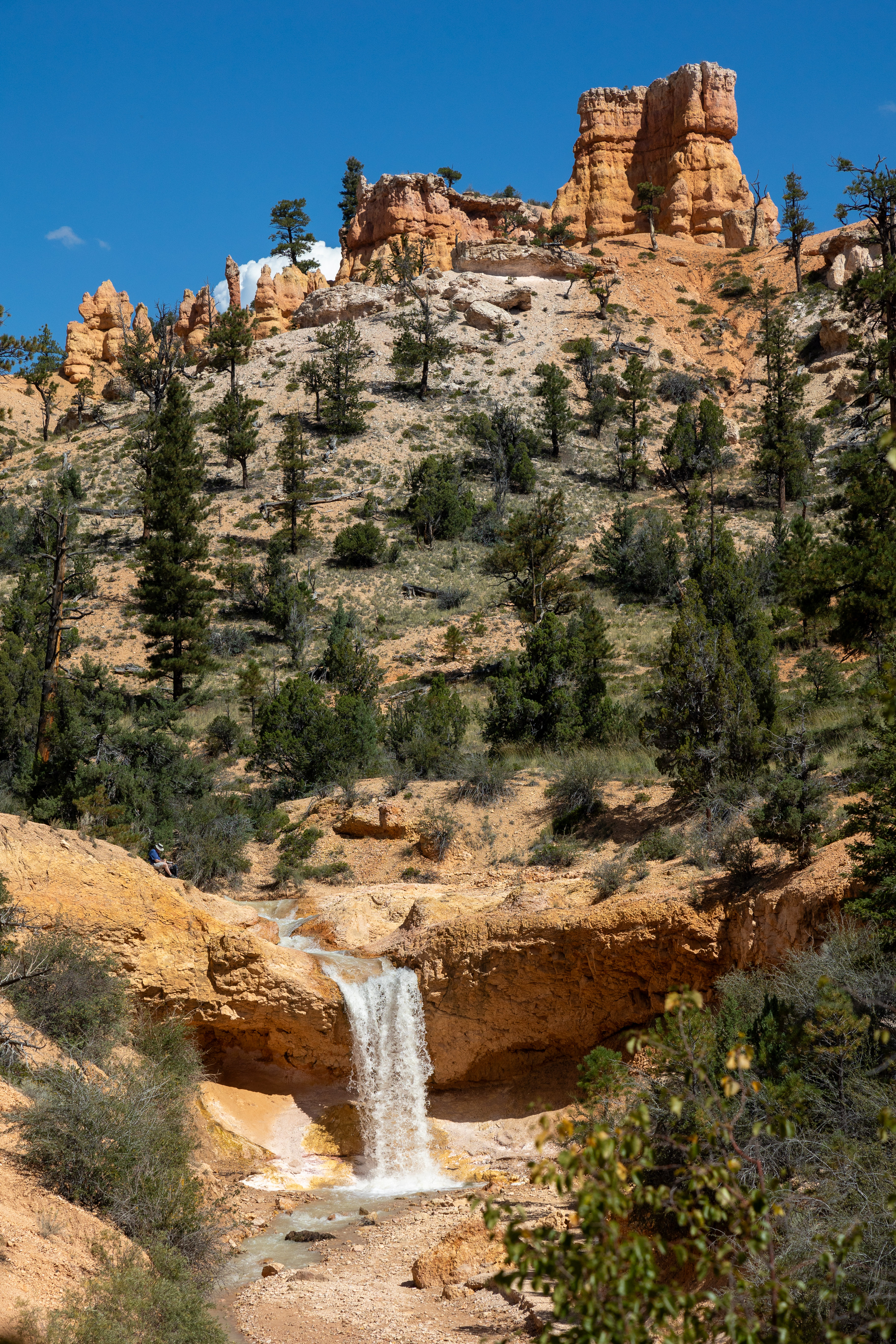
A castle guarding the head of Tropic Ditch Canyon
|
 |
| Tropic Ditch flows begins in Tropic Reservoir roughly 20 miles away. Pioneers hand dug a ditch across the valley, through Bryce Canyon City, to irrigate their crops. |
 |
The first clouds of the day appear over the hoodoos. Time to move along.
|
 |
| Tropic Ditch |
 |
Tropic Ditch Falls
|
 |
| This fin sits above the falls and has 6 windows. |
 |
We made it back to Nakai as the hail and rain began.
|
 |
More storm clouds are gathering beyond Powell Point.
|
 |
Desert storms are stunning!
|
 |
This is the same Powell Point we saw from the Bryce Canyon overlooks.
|
 |
| The monsoon is gathering strength over the Badlands. |
 |
And it begins!
|
 |
We decided to cut our day short.
|
 |
But the flowers love these cloudbursts.
|
On Tuesday, it was time to leave Bryce Canyon. It has been a good week, but the anticipation of the week ahead made the going easier. But, before reaching Capitol Reef National Park, we had to get around the Aquarius Plateau shown in the photo. This is the highest plateau in North America at just over 11K feet. It sits at the top of the Grand Staircase that reaches all the way down through Southern Utah and into Arizona, ending at the Grand Canyon. It includes some of the most spectacular scenery that America has to offer. But we can’t go over it! We can go East along the precipitous HWY 12, but Koko would not like the arduous grades. Or we could go the Western Route. We chose the latter through a small valley with a few steep inclines but nothing like HWY 12. This was a beautiful drive and was the kind of driving that I really enjoyed with Koko.
This is a small portion of the drive around the Aquarius
Plateau through an old mining area. This is classic blue line driving, following
the secondary roads that used to be marked with Blue Lines on
paper maps.
After our 2 ½ hour drive, we arrived at our home for the next week. This is Wonderland RV Park in Torrey, UT. This park is phenomenal. It is small but has many unique features that will stand out in our memories. The streets are lined with fruit trees (a nod to the original Mormon Settlers who grew fruit in the Fruita Valley along the Fremont River.) A pasture next to the park has a Bison and calf, a horse, a donkey, and a cow. The mountains sit in the background, with a lush valley filling the space between. We are just over 10 miles from the National Park, at the intersection with the other end of HWY 12. This is going to be a great week.

 |
Viginia Creeper one the fences.
|
 |
Apricots are not quite ripe.
|
 |
Chokecherries for making jam
|
 |
The peaches were not as sweet at Stonewall Peaches in Texas. But they were delightful nonetheless.
|
 |
The Apples were delicious!
|
 |
So were these, but a bit more tart!
|
 |
A variety of Crab Apple offered shade on our site.
|


 |
Capitol Dome from the head of the trail. (Hint: There is a dirty little secret about this feature!)
|
 |
The Fremont River at the trailhead.
|
 |
Heading Up the Cliff Face
|
 |
Through the high country
|
 |
An ancient land
|
 |
The vistas were grand!
|
 |
But the "smalls" were an equal joy!
|
 |
A life-giving puddle
|
 |
Thishole in the rock that hides a surprise.
|
 |
The creek runs through the rock below these holes.
|
 |
Into the back canyon
|
 |
Our first glimpse of Hickam Bridge.
|
 |
A natural land bridge
|
 |
This local was a little too bashful to give much information.
|
 |
A beautiful piece of nature's architecture
|
 |
The trail beyond
|
 |
Overlooking the northern part of the park.
|
 |
We took our shade wherever we could find it!
|
 |
Yes, that is the trail.
|
 |
A topsy turvy world.
|
 |
Rabbitbrush is a mainstay for life in this arid land.
|
 |
The ages flow like brief moments in a day.
|
 |
But still, life abounds!
|
 |
The trail back down toward the river.
|
 |
Back tothe Fremont.
|
Pie for lunch! After our hike, it was time for lunch. We drove to Fruita and grabbed lunch at the Gifford House, where the menu consisted of fruit pies. These are made from fruit harvested from the orchards that fill the valley. They had Apple (but were sold out), Strawberry Rhubarb, Cherry, Peach, and Mixed Berry. Marlene had a peach, and I had a cherry pie. We also shared some vanilla ice cream to "round out" lunch! For dessert? We took a Strawberry Rhubarb pie back to Koko. We were now well-fortified to take on the Waterfold Scenic Drive.
The Waterfold Scenic Drive took us through Historic Fruita and then along the cliff face, where the uplift and fold created the signature scenery for the park. We drove the Grand Wash Road and then went over the Slickrock Divide before descending to the Capitol Gorge Road. After our morning hike, our legs and knees were in no shape for more hiking, so we stayed close to the road and enjoyed some beautiful scenery.
 |
The cliffs beside the Fold.
|
 |
Soaring escarpements
|
 |
Gorgeous layered cliffs
|
 |
A grand uplift raises our sights from our little world.
|
 |
Deep canyons
|
 |
A Miner's Camp
|
 |
Closed Uranium Mines from the 1950s.
|
 |
Deep in a wash
|
 |
Peering inside
|
 |
Beware, radiation!
|
 |
Signs of a topsy turvy past is everywhere.
|
 |
A geologist's fantasy land
|
 |
Millions of years of earth history
|
 |
And the hoodoos keep dancing in the sun.
|
 |
Beyond gorgeous
|
We rose early to make the Cathedral Valley Drive in Nakai. This is a 56-mile loop that follows Hartnett Road along the East Side of the Ridge to Cathedral Valley and then returns along Cathedral Road. This is a high-clearance road, and Nakai was in her element. It is only passable during dry weather. Your vehicle must ford the Fremont River. It was only a foot deep when we went through. But during sudden storms, it can quickly become several feet deep. Also, the road takes you through the Bentonite Hills. This clay becomes very slick when wet, and you will not climb them, 4WD or not. We had checked the forecast and took our shot at making the loop. It was a perfect day to explore this northernmost part of the park. The 8-hour drive has a WOW factor that is right up there with Shaffer Drive in Canyonlands National Park.
 |
It begins with crossing the Fremont.
|
 |
Welcome to the trail!
|
 |
Rising high above us
|
 |
Into the Bentonite Hills
|
 |
Bentonite has been used for centuries to cure all kinds of medical maladies.
|
 |
Across the desert is more desert.
|
 |
Deep washes
|
 |
Long stretches of sand and gravel
|
 |
An oasis from the cattle grazing years
|
 |
A drilling Rig abandoned in the desert
|
 |
"There's your problem!"
|
 |
Yes, it is very, very dry.
|

 |
More Bentonite
|
 |
When wet, these roads through the bentonite is absolutely impassable. Even Nakai would have to turn around because the roads would be slick as glass.
|
 |
Beauty breaks through the already radiant bentonite.
|
 |
Avast and multicolored landscape
|
 |
The desert floor
|
 |
Jailhouse Rock rises above the desert.
|
 |
Color fills the washes
|
 |
Getting ready to head down into the desert.
|
 |
| Fins |
 |
Sweeping Cliffs
|
 |
These fins are not as thin as they appeared from high above.
|
 |
the largest fin, head on
|
 |
Cathedral Rock
|
 |
The Gypsum Sinkhole was formed when a plug of gypsum dissolved and left a 50 foot wide and 200 foot deep hole in the desert.
|
 |
Rock adorn the tops of many fins.
|
 |
Lava clings to the side of a fin.
|
 |
The lava and the fins are slowly crumbling away.
|
 |
Tire tracks through the washes
|
 |
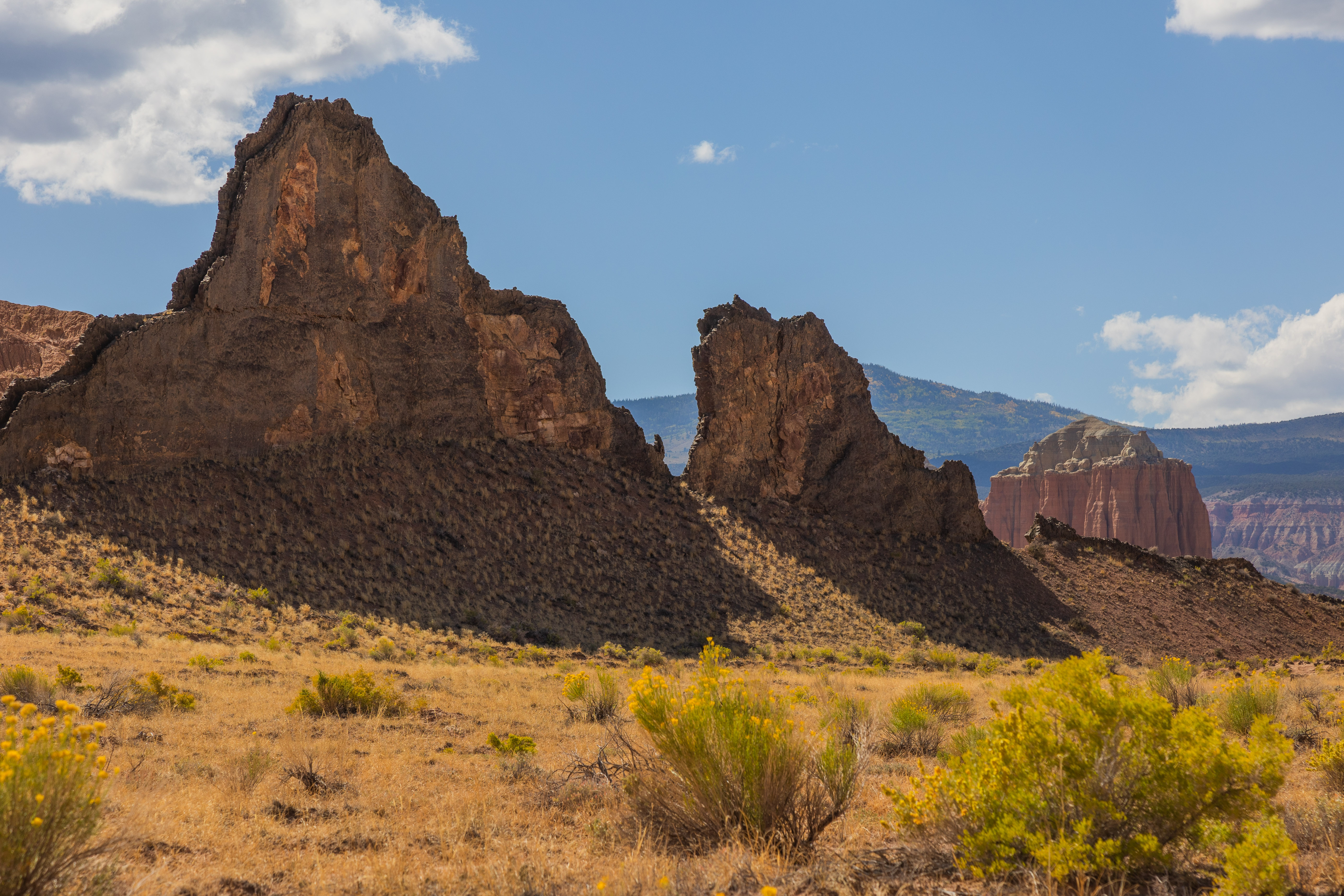
The Temple of the Moon
|
 |
The much larger Temple of the Sun sits in the background.
|
 |
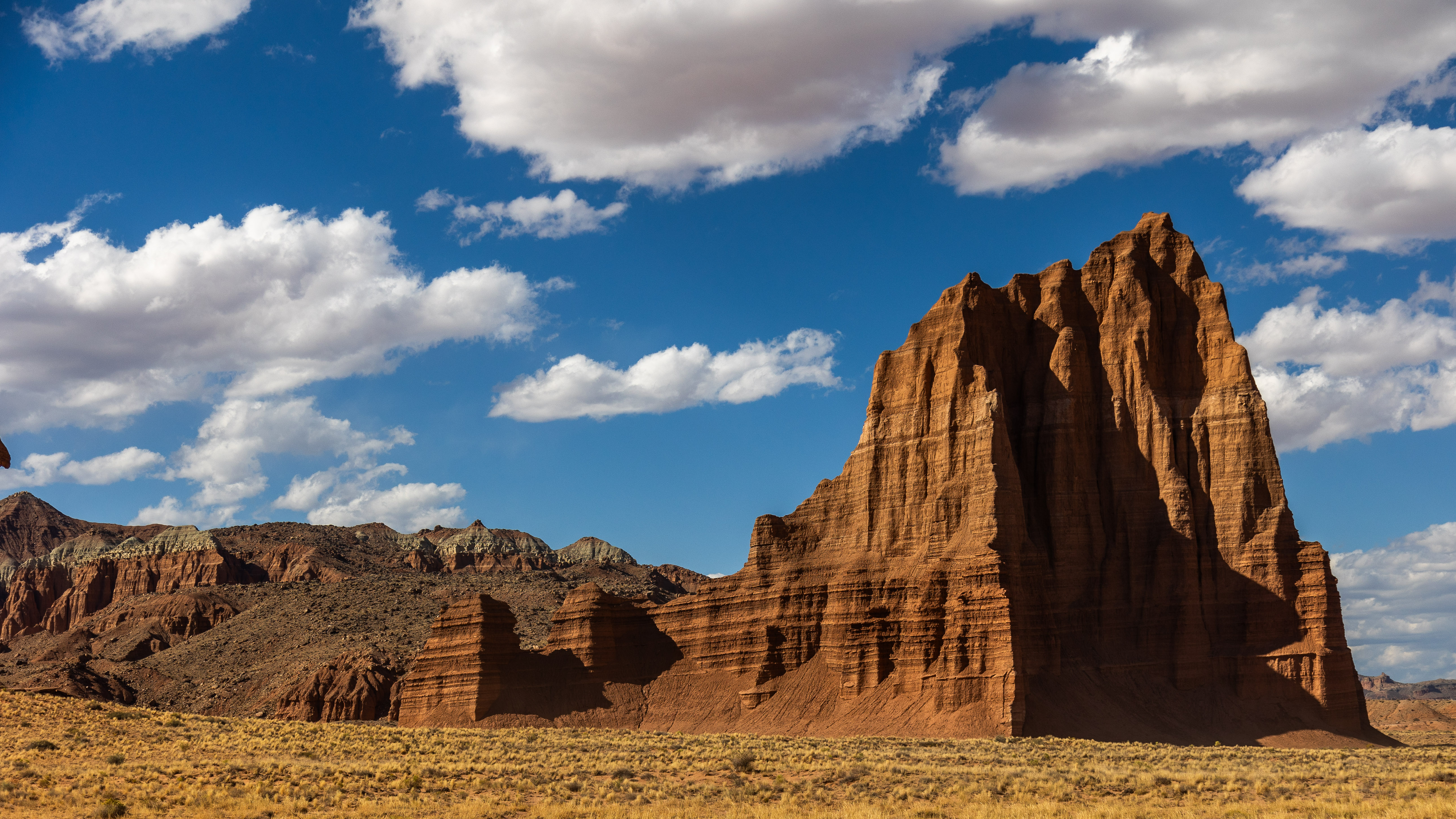
The Temple of the Sun
|
 |
Glass Mountain sits in front of both temples.
|
 |
The crystallized gypsum creates the small glass mountain.
|
 |
Both Temples reaching up to the heavens.
|
 |
On the backside of the trail we see the Bentonite Hills once again.
|
 |
Vast, open desert vstas are all around.
|
 |
Through the hills
|
 |
The setting Sun highlights the Reef as we head for Koko.
|

 |
The fault that marks the fold in the earth's crust at Capitol Reef
|
 |
The grandeur of this park is overwhelming.
|
 |
Even the small details inspire curiosity.
|
We stopped at the Petroglyph Site before resuming our sightseeing. These petroglyphs were left by the Fremont People over 1,000 years ago. The meaning of the symbols etched on the cliff face has yet to be discovered. Different tribal sources ascribe different meanings and significance. We have seen petroglyphs all over the Southwest. But this collection is among the most interesting. They provide a sense of movement and tell something of a story as they follow the base of the canyon wall. I can imagine the strong hands that worked for hours inscribing their life experience along this river. Seeing and photographing these works of art was a highlight of our year on the road. This is a large part of the entire panel. The pictures that follow offer details of the images along the cliff base.
 |
The Fremont Valley. Wouldn't you want to spend your Summer's here?
|
 |
The triangular human forms are iconic Fremont style.
|
 |
The Bighorn Sheep run the length of this panel.
|
 |
Some more recent "artwork" (graffiti) left by early settlers.
|
 |
What do you see in this panel?
|
 |
The fold
|
What is that dirty little secret I mentioned at the top? The Capitol Dome, for which the park is named, is not a dome at all. From the East or West, it looks like a dome, but from the South along HWY 24, it is actually a series of fins lined up in such a way as to give the illusion of a dome. This is a picture of the Capitol Dome from the highway! But don't tell anyone. I wouldn't want the National Park Service to cancel my Senior Pass.
Autumn has begun. We began our Summer in Washington State as the young Salmon headed to sea for the adventure of a lifetime. The unknown was before them, and they could only wander until they returned at the end of their life at sea to the same streams to fulfill their destiny. Marlene and I began a journey together 50 years ago. We have lived our lives in a vast sea of previously unknown experiences. That journey continues. Even though Autumn has begun, we are not yet ready to return to the headwaters of our lives. We have miles to go before we return to live out our destiny. Many unknowns await us as we make our way South for the Winter before we set forth again on a new adventure in 2024
As the weather cools and we all settle into our Autumn routines, may each of you celebrate the road ahead. There is much to see, experience, and learn. Be prepared for awe and wonder to be your daily companions. Come on along and enjoy the adventure as our wanderlusting ways continue. We will head to Monticello, Utah, and beyond in the coming week.
Glad you are along for the ride!
Bob