Traveling vs. Camping! We are primarily travelers looking for
a place for our home on wheels. And the last week has taken through some truly remarkable
landscapes. I have taken well over 1,000 pictures and am
finding it very difficult to pick out a few favorites for the week. So I will
feature mostly photos this week with minimal commentary. So, as best as an old preacher
can, I will let the pictures tell most of the story.
We started our week in Springdale Utah and made another
trip to Antelope Island State Park on the Great Salt Lake.
 |
| Look closely and you will see this poor Gull surrounded by thousands of beach flies. Those black flecks are flies! Glad we never made it to the Salt Lake Beach. |
|
 |
This handsome Pronghorn greeted us on the way to the Visitor Center. Look at his nose and you will see his relationship to rabbits!
|
 |
Speaking of, meet his Cousin Jack!
|
 |
This big fellow was minding his own business taking a nap when we got a little too close. He got up in a cloud of dust and we retreated to the rocks behind us. "Go back to your nap. I understand how important those are, especially on a warm afternoon!"
|
 |
The bison have a barn where the Park Rangers keep their feed. This Female Great Horned Owl lives there and raises her family on the inevitable mice and lizards that scamper around the bales of hay.
|
 |
This tiny lizard has one job, Survival!
|
 |
The Avocet migrates though out North America.We may see this young bird next Winter in Texas!
|
 |
These Barn Swallows love the breeze off the Great Salt Lake as well as all the tasty flies that fill the air!
|
 |
You have to admit, that does look like fun!
|
 |
So long, Great Salt Lake! I have enjoyed getting to know you!
|
 |
We got off to a bumpy start on our drive to Willow Wind RV Park in Hurricane, UT. Got Koko and Nakai stuck in he middle of a road when I couldn't complete a u-turn. When towing Nakai I can't back up. We had to unhook. Then, when arriving, we had to change site when the first one was too uneven for Koko. But, we finally made it and have been enjoying our stay ever since.
|
 |
Welcome to Zion National Park. We were here in 2007 but did not go into the Canyon. We drove this Hwy 9 to the East Entrance. On our first day in the park we repeated this drive and saw some of the iconic beauty of what was originally known by it's traditional Paiute name, Mukuntuweap National Monument but was changed to Zion in deference to the local Mormon leaders a year before the park was founded. This is the central canyon formed by the Virgin River.
|
 |
| This is one of the features I remember from 2007. The Arch and the bands of color at the top fascinated me and ignited my curiosity about the geology of the Southwest. |
|
|
 |
This stunning Desert Bighorn Sheep Ram was keeping a vigilant watch over his herd as they moved down the mountain side. He and his ewes are magnificent creatures who have made this desert their home.
|
 |
This is Checkerboard Mesa known for the crosshatching on the slope. It was another of those features that ignited my fascination with geology. The horizontal lines were etched by winds that blew along the surface of massive Sand Dunes that surrounded this harder rock. The vertical lines were caused by compression and retraction of the surface in the cold and heat of the desert. The lines have been enlarged by wind, ice, and rain. These places continue to set my imagination afire.
|
 |
The Virgin River flows through the Park. It is responsible for the depth and width of the canyon. In the Spring and Fall it can carry massive amounts of floodwater and sandy silt that cuts its way through solid rock and are responsible for most of the features along the canyon walls.
|
 |
It is always good to see an old friend from home. This Great Blue Heron was patiently waiting for something to swim by his rock in the middle of the river. As the old saying goes, "That's why they call it fishing and not catching."
|
 |
| The next morning we got up before dawn in order to get a parking space at the visitor center. We caught the tram into the canyon. The sun welcomed us on the ride in greeted us from high above. It was the start of a magical day of hiking and photography. |
|
|
The river cuts through the canyon and leaves gravel beds at every bend. It moves huge boulders, trees, and anything else that tries to slow it down. Here the water takes on the magic of the light on the walls. There is magic all around us in this place.
|
 |
The walls are lined with ferns and lush vegetation that depend on the seeps that drip from the cracks and crevices. They only get direct sunlight for a few hours at midday.
|
 |
Marlene at one of the many narrow stream beds where the water finds it way through the boulders that it carried downstream.
|
 |
This is a red lobelia commonly called the Cardinal Flower. It grows out of the walls near seeps with same limited soil.
|
 |
Part of the magic of Zion is that the sunrise lasts nearly all morning as the light reflects off the high canyon walls.
|
 |
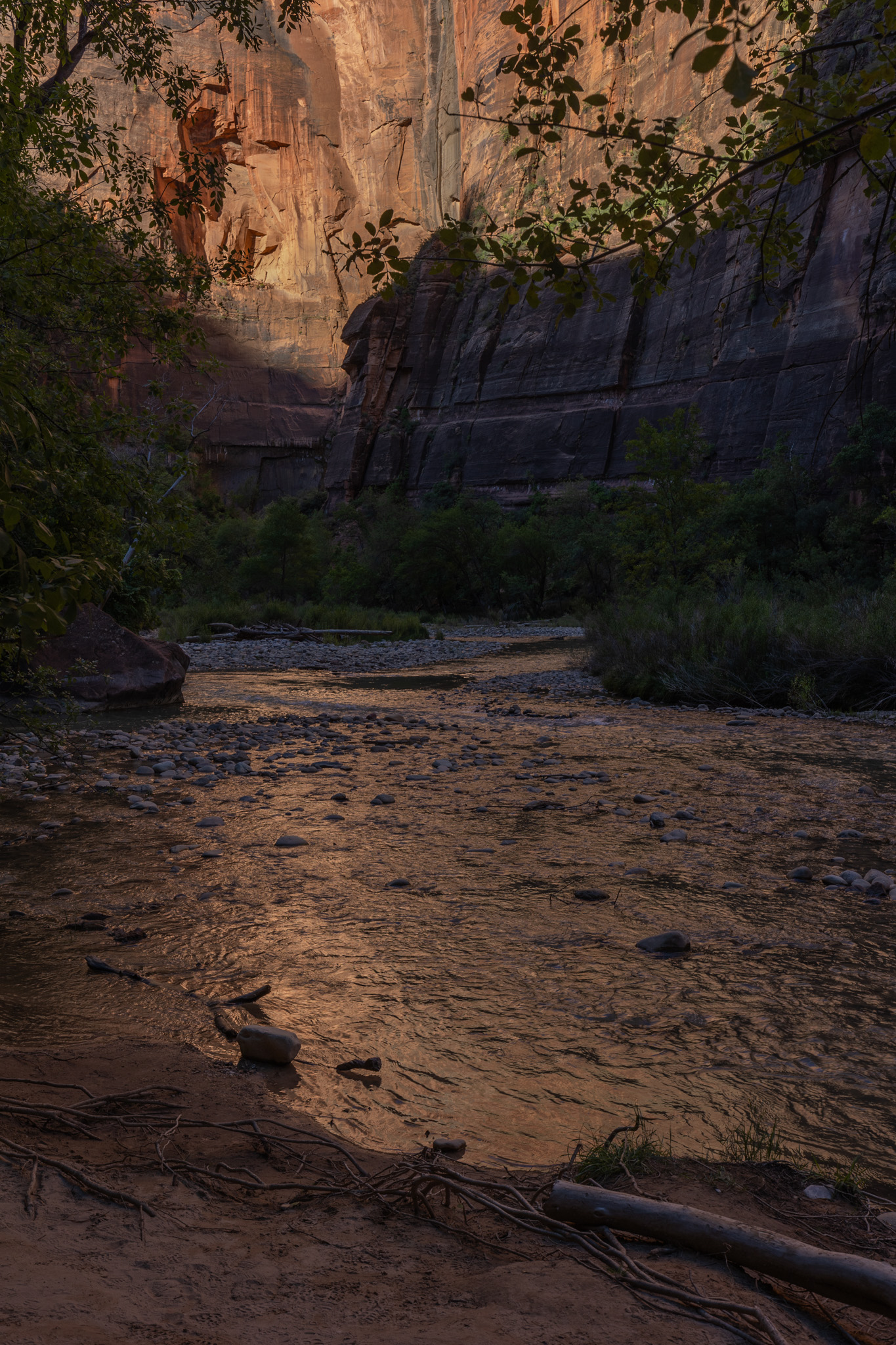
| The enchanted light even paints the water, deep in the canyon! |
|
|
 |
| Light dancing on the waters! |
|
|
|
|
|
|
|
 |
| The sky shares its pallet with the water as well. |
|
 |
My intrepid companion is just getting started and we have miles to go before we get back to the Visitor Center.
|
 |
The Sacred Datura, also known a Jimsom Weed, is so-named because it's poisonous sap was powerful spiritual medicine for the Native People.
|
The Weeping Rock is a large seep in the Canyon Wall.
 |
| The color and textures in this seep are incredible. |
|
 |
| The flowers love the seeps and the small streams that flow from them. |
|
|
 |
| You are looking at the end of the most famous trail in Zion, Angel's Landing. It is named because early visitors believed that only Angels could land there. Did we climb it? I ain't no angel! |
|
|
 |
This beautiful creature graced us with a visit on the trail back to the Visitor Center. She is very comfortable in her home.
|
 |
Here we are back at the Visitor Center on the Virgin River. It has been a long and wonderful day.
|
 |
The red rock in the background is the Kayenta Formation. But the thin gray band in front of it is the only known, commercially feasible sandstone that holds silver chloride. It is called the Silver Reef and is the reason that a large town grew up and died here in the desert over one hundred years ago. Welcome to Silver Reef, Utah.
|
 |
| This gulch between the Kayenta and the sandstone holds Leeds Creek. It provided the water needed for mining and processing the 405 mines that operated in this area in the late 1800s. The water flowed out of the mountains and hit the red rock and flowed out of the hillside into the anticline. It carried the softer sandstone away and exposed rich veins of silver chloride which supported a generation of miners. |
|
|
 |
| This is the original Wells Fargo office that offered stage coach service, freight for the processed silver, and banking. They also served as agents for selling the silver to the US mint. It was the lifeblood of the town of Silver Reef and transformed the scattered pioneer families that farmed the bottom lands into a cash economy that relied on the mines and miners. |
|
|
 |
| This Rock Wren is one of the seasonal residents of the town and is welcoming us with a song! There are a few wealthy folks who have built homes among the ruins, but most of Silver Reef is a ghost town. |
|
|
 |
| These ruins of a fine home that overlooked the valley, was built by Capt. Henry S. Lubbock who was the superintendent for the Christy Mill. The trees surrounding it are likely direct descendants of the original Chinese Sumac brought by immigrant workers from China. |
|
|
 |
| This is the original jail for Silver Reef. Most of the old buildings were torn down and the wood and stone repurposed for other structures. But this building was moved several times before being relocated here on Main Street by a local Eagle Scout. |
|
|
 |
| These are the original walls and floor of the jail. Good job, Eagle Scout! |
|
|
 |
| The Barbee Walker Mine stood close to town. The mill sat just across the creek. |
|
|
 |
An abandoned mine shaft
|
 |
| A sealed open mine shaft |
|
|
|
|
|
 |
| The remaining chimney from one of the five mills in the area that processed the silver ore and sent the refined silver to the US Mint via Wells Fargo Stages and Wagons. |
|
|
 |
| This Charcoal Kiln sat in the mountains behind the mines. It processed wood cut from the forest and produced charcoal that was used to heat and process the ore. The charcoal burned hotter and was easier to transport than wood. |
|
|
 |
The modern trail to the kiln was built with the help of local elementary schoolchildren. The signs were written by the children.
|
 |
The Manzanita Bush
|
As the sun began to set, I took a few landscapes in the golden light. Thus ended a wonderful week that began with our last day at the Great Salt Lake and ended with our first few days here in Southern Utah. There is much more to come. Enjoy these few shots as I bid you farewell for now!
Bob
 |
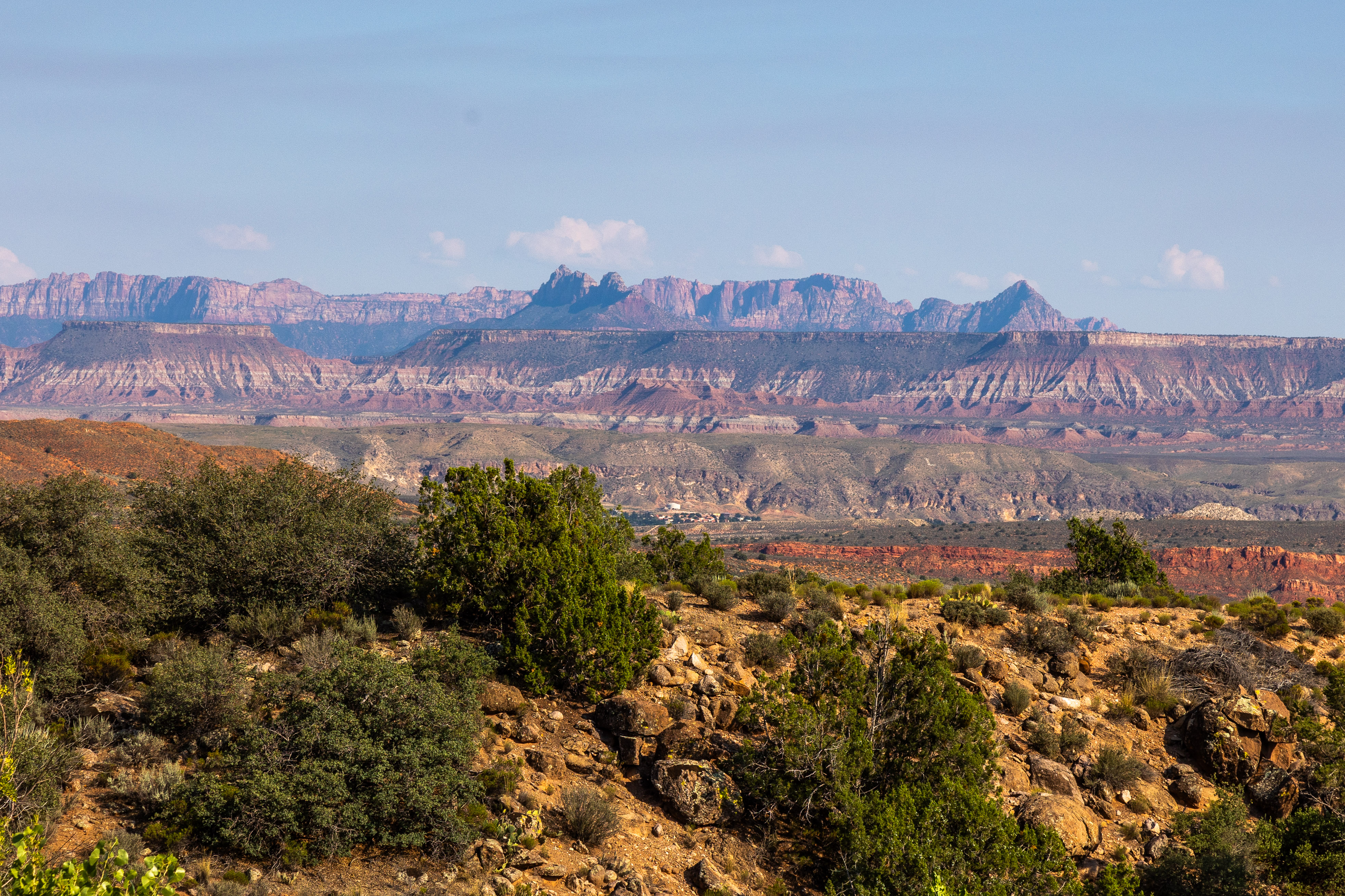
An Anticline, much like the one that eroded away after being fractured by the buckling earth.
|

 |
Zion National Park, 20 or so miles away.
|


No comments:
Post a Comment