We
finished our week in Hurricane and packed up to find our way to Bryce Canyon
City. We knew that we were facing thunderstorms in Bryce Canyon City around
12:30. The drive was only 2.5 hours, so we hit the road by 9:00. The drive was
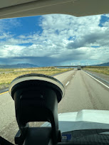
uneventful, with only a little rain along the way when we skirted the rain you
see in the picture. I found a new website called Flattest Route that helped me
find a route with the lowest grades through Southern Utah. It worked well, and
we arrived in time to set up. After finishing up, I felt the first raindrops
when I headed into the Koko.

We are looking forward to our week as guests of Ruby's kids.
Red Canyon is part of the HWY 12 Scenic Drive. It is a small
but fabulous canyon cut through the Kayenta Sandstone. We took two short hikes
among the hoodoos and learned that “hoodoo” comes from the childhood words for
spooky. The elders told them that the pillars of rock were their ancestors
keeping an eye on them, to which they would respond with a lyrical “oooodooo.” We walked among these red pillars and boulders
and joked with several other hikers, "Walk 10 feet and snap three pictures
as you turn around." It is an incredible experience to be among such
natural beauty.
 |
Marlene Climbing through the rocks!
|
 |
A colorful pallet of rocks
|
 |
Scarlet Gilia
|
 |
The Red Canyon Walls rule the vista!
|
 |
The Salt and Pepper Hoodoos Stand Guard over the Canyon.
|
 |
A Canyon Trail
|
 |
Navajo Limestone of Kayenta Sandstone
|
 |
The Valley View from the Canyon
|
 |
A Rock Face
|
 |
Salt and Pepper from a Different Perspective
|
 |
A Balanced Rock hanging onto to the Canyon wall.
|
 |
Pretty little Blue Berries.
|
 |
Yep, that is how steep the trail was at times!
|
 |
Hoodoos across the way. So long, Red Canyon!
|
Lake Panguitch is a natural lake that was enlarged with a
24-foot dam on the Sevier River in Southern Utah. It sits at 8,200 feet. On our
drive up the canyon, we actually saw the first snow of the season on the
ground. Looking closely in the lower left corner and you will see how high we were above the lake. That
tiny speck in the water is a fishing boat.

 |
Cedar Breaks is a multi-layered experience.
|
 |
A creek that forms part of the Sevier River watershed.
|
 |
An Alpine Valley and 10,614 feet.
|
 |
The Chessmen of Cedar Breaks
|
Texas BBQ! (Sort of) After our afternoon at Cedar Breaks, we
sought out a BBQ joint we found in Panguitch on our trip in 2007. They use
mesquite wood that they import from New Mexico and Texas. The original owners
were from Central Texas. The BBQ was very good, but they have abandoned brisket
in favor of tri-tip. It was well prepared, however. There was plenty of flavor
in the meat. No sauce was necessary! It was worth the stop, especially the
cinnamon bread pudding with fresh whipped cream.
Panguitch is an old town settled by the Mormons in the
1800's. Their first attempt was abandoned after the extreme cold at the high
altitude destroyed their crops and sent the men off in the winter snow to get
emergency supplies from nearby towns. Better preparation led to a second
attempt that succeeded. The town sits in the Sevier River Valley, becoming a
gateway for Cedar Breaks and Bryce Canyon.
I am a big fan of skies with clouds. Southern Utah has had
some wet weather during this monsoon season, and the clouds have been
spectacular. Generally, the clouds gather after lunch as the afternoon
thunderclouds build. The deep blue sky is filled with white-to-gray clouds over
the lush green and red landscape below. You will see more clouds in the Bryce
pictures to follow, but I love them even when they sit over a green forest.

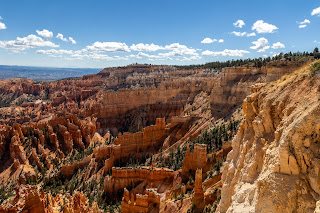
Bryce Canyon sits along the Paunsaugunt Plateau at the edge
of the Sevier and Paria River Valleys. It features the deep red Kayenta and
gray-to-white Navajo Sandstone and several other layers that are exposed during
the uplift. The most distinctive feature is the hoodoos (mentioned earlier in
the Red Canyon.) They are formed when rain and wind erode the softer Kayenta
Sandstone from beneath a more rigid "cap" of Navajo or other rock.
They sit among amphitheaters of shelves, arches, pillars, and other features
that create a striking and memorable vista. The National Park consists of a
16-mile Scenic Drive. The first few stops are so popular that most people use
the free shuttle to experience their beauty. We were here in 2007 and are
enjoying our repeat visit as much as our first. The first set of pictures are
from stops along the Scenic Drive. The second set is from our hike along the
rim. Enjoy!
The Scenic Drive
 |
This little tree was a beautiful Christmas Tree 16 years ago. Time has had its way, as it always does.
|
 |
Natural Bridge Arch
|
 |
The Valley Beyond
|
 |
Can you find the hidden window?
|
 |
A old stump, weathered by fire, rain, and ice, clings to the rim.
|
 |
A tiny natural castle on the valley floor.
|
 |
A multi-colored pillar
|
 |
Marlene sees two faces. I see someone mooning the guests!
|
 |
A Noble Raven calls from the tree tops!
|
 |
Afternoon Storm Clouds gather as the Summer Monsoon Season continues.
|
 |
The end of a lovely day
|
Along the Rim
 |
Point Powell
|
 |
A Natural Cathedral at Bryce Point
|
 |
Bryce Creek running through the Bryce Point Amphitheater
|
 |
Looking toward Aquarius Point
|
 |
A Clark's Nutcracker getting a drink from a puddle after the Summer Rain
|
 |
Sunrise Point
|
 |
Sun and Clouds, Mesas and Valleys. Wow!
|
 |
Marlene is looking for Cell Service so that she can share the view with the Grands!
|
 |
Between Sunrise and Sunset Points
|
 |
A Wonderland of Color
|
 |
A Chipmunk on clean up duty.
|
 |
Limestone Hoodoos
|
 |
Sunset Point
|
 |
The trail into Wall Street Trail. We took this trail is 2007. This is the gentle part of the trail!
|
 |
Wall Street
|
 |
|
The Rock Conglomerate protects the underlying softer
sandstone and creates the hoodoos and all the other features. They do not stop
the erosion. They only slow it down.
|
 |
The trail not taken. Need I say more?
|
 |
A Rocky Rainbow
|
 |
Fins, Walls, and Hoodoos
|
 |
That highest peak is where we took the next few pictures. Yes, it was worth the climb!
|
 |
Aquarius Plateau is the highest platea in North America at 11, 328 feet. The landscape descends all the way down to the Grand Canyon, far to the South.
|
 |
Layered Hoodoos
|
 |
Natural Flying Buttresses
|
 |
Time for a break at 8,000 feet.
|
 |
|
A
Tree Trying to get a better view over the edge. Actually this shows the continuing erosion that is inches a year.
|
 |
A Hoodoo watches over the valley.
|
 |
Bryce Creek Valley at Inspiration Point
|
 |
Inspiration Point Anphitheater
|
 |
It has been a great day along the Rim of Bryce Canyon National PArk.
|
 After a full day in the sun and at 7,000 to 9,000 feet, it
was time to take a break. We went into town, had a good dinner, and crashed. It
has been a wonderful week. I have taken over 5,000 pictures with the new camera
and enjoyed every minute. We have a few more days here in Bruce Canyon before
moving to Capitol Reef for a week. But before we go, thank you for all your
comments on FB. I hope you have enjoyed this new format for the blog. Please
share your comments, gripes, reflections, and ideas on FB or in the comments.
It is always a thrill to hear from you.
The road continues, and I am grateful to have you along.
Bob


 After a full day in the sun and at 7,000 to 9,000 feet, it
was time to take a break. We went into town, had a good dinner, and crashed. It
has been a wonderful week. I have taken over 5,000 pictures with the new camera
and enjoyed every minute. We have a few more days here in Bruce Canyon before
moving to Capitol Reef for a week. But before we go, thank you for all your
comments on FB. I hope you have enjoyed this new format for the blog. Please
share your comments, gripes, reflections, and ideas on FB or in the comments.
It is always a thrill to hear from you.


No comments:
Post a Comment