Wandering, by definition, does not follow a straight line governed
by a destination. This week, we started The Big Zig, the first of several for
this trip, as we turned away from the Great Lakes to explore downstate
Minnesota and Wisconsin for a few weeks. We will do The Big Zag when we return
to Lake Michigan after our wandering down I 35 and beyond is done.
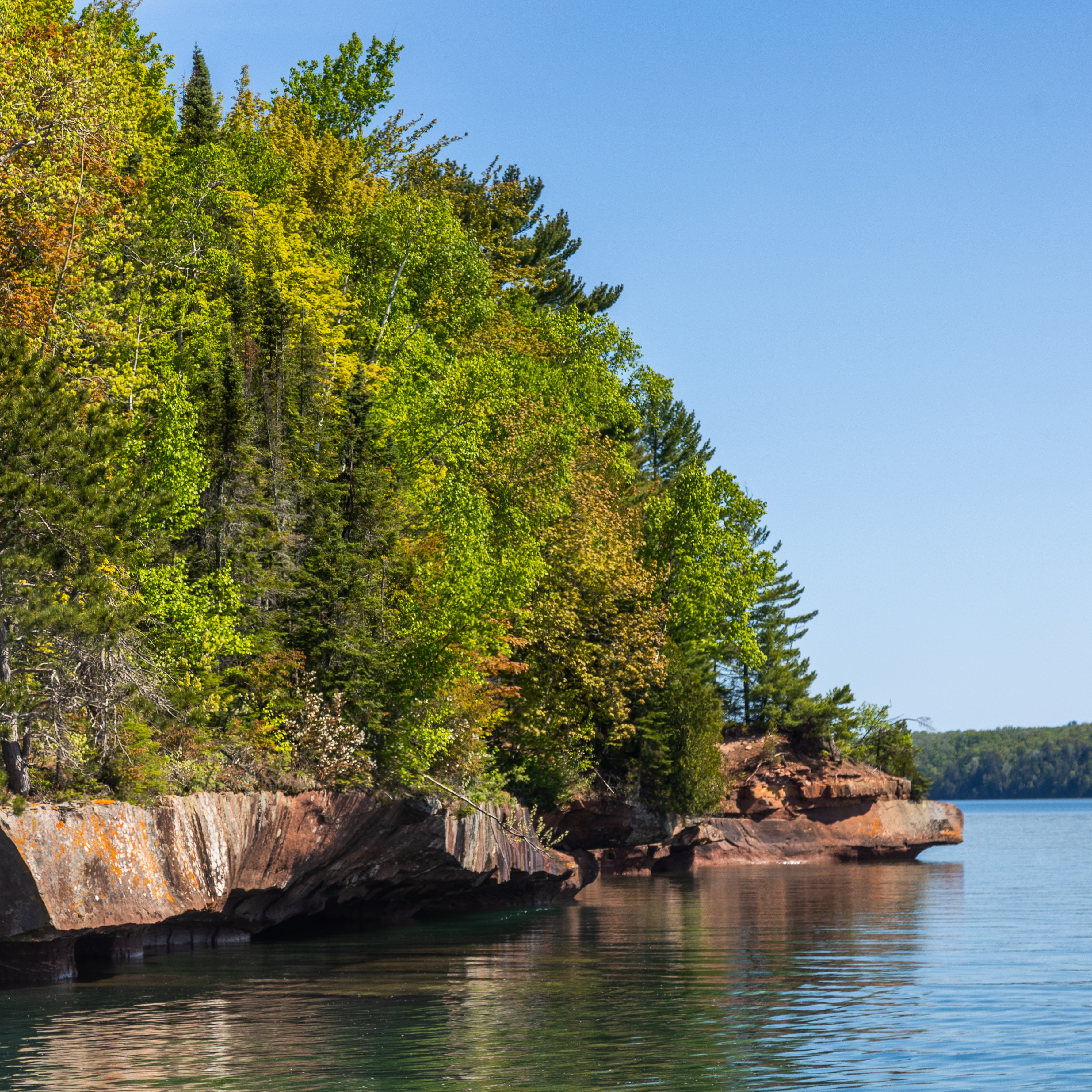
We began our week in Bayfield, WI, on the shores of Lake
Superior at the Apostle Islands. The Apostle Islands are an archipelago where
Lake Superior's waters have eroded the Bayfield peninsula's end. It includes 23
islands (only 22 are part of the National Lakeshore.) Lake Superior (like Lake
Ontario) is extraordinarily deep, too deep to have been formed by glaciers.
They were formed long before the Ice Ages when a rift opened in the middle of
the North American Plate. There was insufficient force to cause a complete
separation in the continent. It closed when magma flowed in and sealed the tear
in the crust. This left a deep layer of hard, volcanic rock on the surface that
withstood the glacial period. However, the waters left behind when the glaciers
retreated left a large, freshwater inland sea that the early native people
called gichigami, great lake, referring to both its size and central
role in the history of the Ojibwe and Dakota, the who inhabited the islands 950
years ago.
The View from the top of the Bayfield Peninsula
These Ojibwe migrated from the East, and when they discovered wild rice growing in the marshes at the end of Chequamegon Bay, they made Mooningwanekaaning (now Madeline Island) their capital. They lived here for nearly 1,000 years before being forced into reservations by white settlement. At the end of the peninsula is the Red Cliff Band of the Lake Superior Chippewa, unique in having their reservation on their ancestral lands. After internal disagreements over beliefs and traditional practices, many of the original Ojibwe returned to the East, leaving the islands and Lake Superior under the Ojibwe control. The previous residents, the Eastern Dakota people (later called Sioux), were pushed to the West, but many of their creation stories are also centered on this portion of Lake Superior. This has been a place that has inspired the human spirit for 1,000s of years. The Bayfield Peninsula has been a cultural hub for millennia.


Model of the Edmund Fitzgerald 
Norwegian Fishing Boat

 |
| An Ice Saw used on Lake Superior |
 |
| A Salvaged Wreck |

 |
| Birchbark Canoe |
 |
| Marlene at the helm |

The peninsula's North end includes the reservation and a small
community where people discovered that fishing, not farming, was their key to
survival. Sand Bay sits onshore from Sand Island, a popular destination for
kayakers to explore the Apostle Islands. The Ranger at the National Lakeshore
was also a wealth of information about the area's history. She directed us to Beaver
Hollow, a bog with a boardwalk that allowed us to get up close to the land and
water. Sadly, we did not see any beaver, though there was ample evidence of
their being in the area.
Twilite Fishing Boat

For hauling in the nets 
The Captain's Door 
An Old Fishing boat with Tarred nets


 |
| Boardwalk and Bog |


 |
| Marsh Marigold |

 |
| Bog Water is brown from the organic matter |


The following day, we boarded the boat, Archipelago, for a
cruise of the Apostle Islands. This three-hour excursion was a delight. We saw
several of the islands. They support a diverse flora and fauna, including
rookeries for many bird species. One island has the largest concentration of
bears of any place in North America. By the way, bears are excellent swimmers
who move from island to island and to the mainland. One of the notable features
of the islands is the lighthouses. These are no longer staffed by lightkeepers
and are less vital than they were in times before radar and GPS. However, some,
like Raspberry Island Lighthouse, are being restored by the National Park
Service. All but one of the islands are open to visitors, assuming you can get
there, for camping and sightseeing. The archipelago was named by a French
Jesuit, and the main islands were initially named after the Apostles. But
gradually, the islands acquired names relating to their Ojibwe names. For
example, Evil Spirit Island became Devil's Island. Here are a few of the sights
we enjoyed in the islands.
The Archipelago
In the harbor, waiting for time to board.
 |
| Lakefront of Bayfield, WI |
 |
| The Harbor |

 |
| Lakefront Sculpture |

 |
| Our friends came to wish us bon voyage |


Heading out to Hermit Island and the Brownstone Quarries.

Leaving the harbor

 |
| Rocky Lakeshore |

 |
| Those large blocks are Brownstone quarried on Island and sent to St Louis and beyond. |


Heading to Basswood Island

A smooth day for sailing

 |
| The colors are amazing |
 |
| Marlene enjoying the boat ride! |
Heading to Manitou Island.
 |
| Marlene also enjoying the boat ride |
 |
| Bear Island |


 |
| An abandoned Fish camp |

 |
| After dock repair, fishermen can return. |


Heading to Devil’s Island
 |
| Devil's Island is one the edge of the archipelago. |


 |
| The iconic lake caves |


 |
| Devil's Island Lighthouse |


 |
| These caves can reach back over 50 feet from the shoreline. |


On to Raspberry Island.
 |
| The Fully Restored Raspberry Island Lighthouse |
 |
| Lighthouse and living quarters |
 |
| The Fog Horn House |


Heading Back to the Harbor


 |

We picked up some fresh and smoked whitefish from the lake for our last day in Bayfield. I do not remember eating whitefish before. We made a lunch of cheese, smoked fish, crackers, and veggies. The mild, firm flesh was well smoked, and we had a veritable fast. I cannot wait to try cooking the fresh whitefish on the grill. Our time on the Bayfield Peninsula was coming to an end, and it was time to do the jig south to south Minnesota.
We set off to I35 on Tuesday to drive to Minneapolis for the next 7 nights. We arrived at Town and Country Campground and RV Park in Savage, MN, after a pleasant 5-hour drive. Central Minnesota is beautiful, rolling countryside where the evidence of the last glacial retreat is evident. Savage is a Southern suburb of Minneapolis/St. Paul is a convenient base for exploring the Twin Cities. The only real traffic we encountered was due to highway construction, and it was nothing compared to the massive tie-ups in Houston when TXDOT took over a highway.
The Twin Cities sit at the confluence of the Minnesota and
Mississippi Rivers. This has been the site of human habitation for 10,000 years
since the last glacier retreated into Canada. The Eastern Dakota People have
lived here all that time. In fact, their oral history does not include a time
when they migrated to this area. One of their creation stories centers on an
island at the confluence. In addition to the Dakota, the region has hosted
Ojibwe, Voyageurs, British Fur Traders, American Settlers, Farmers, early
Scandinavian Immigrants, merchants, industrialists, and immigrants from all
over the world. The most notable features are the creeks, lakes, and rivers
that define the area. There is much to see and do during our brief week here.
Minneapolis in the distance surrounded by lakes.
Our first full day was forecasted
to rain, so we went to the best indoor attraction we could find, the Mall of
America. This Mall is huge. In a time when enclosed malls all over the country
are closing, this one is thriving. It is a four-story major shopping area
surrounding an indoor amusement park that Nickelodeon runs. We rented a scooter
for Marlene and set out walking the perimeter. I logged 8,000 steps with
minimal backtracking. It is a typical suburban mall with the usual suspects of
stores and items for sale. We did a little shopping, but we mostly
window-shopped. We ate lunch at a Margaritaville Restaurant and then did more
exploring. When we got to the middle, we discovered that the rides were not
little kiddie rides. There were a few, but there was a three-story plume ride,
a three-story rollercoaster, and rides that flung you around and bounced up and
down. There was also a crayon Shop and Lego Store that were unbelievable. The
latter contained a fifty-foot-long green dragon constructed entirely of Legos. It
was an interesting way to spend a cloudy, windy day in the Twin Cities. Here
are a few photos.
Marlene Ready to take on the Mall

The head of a 50 foot dragon 
20 foot tall transformer 
Time for a break 
Ahhhhh.... 
Log Ride in the mall 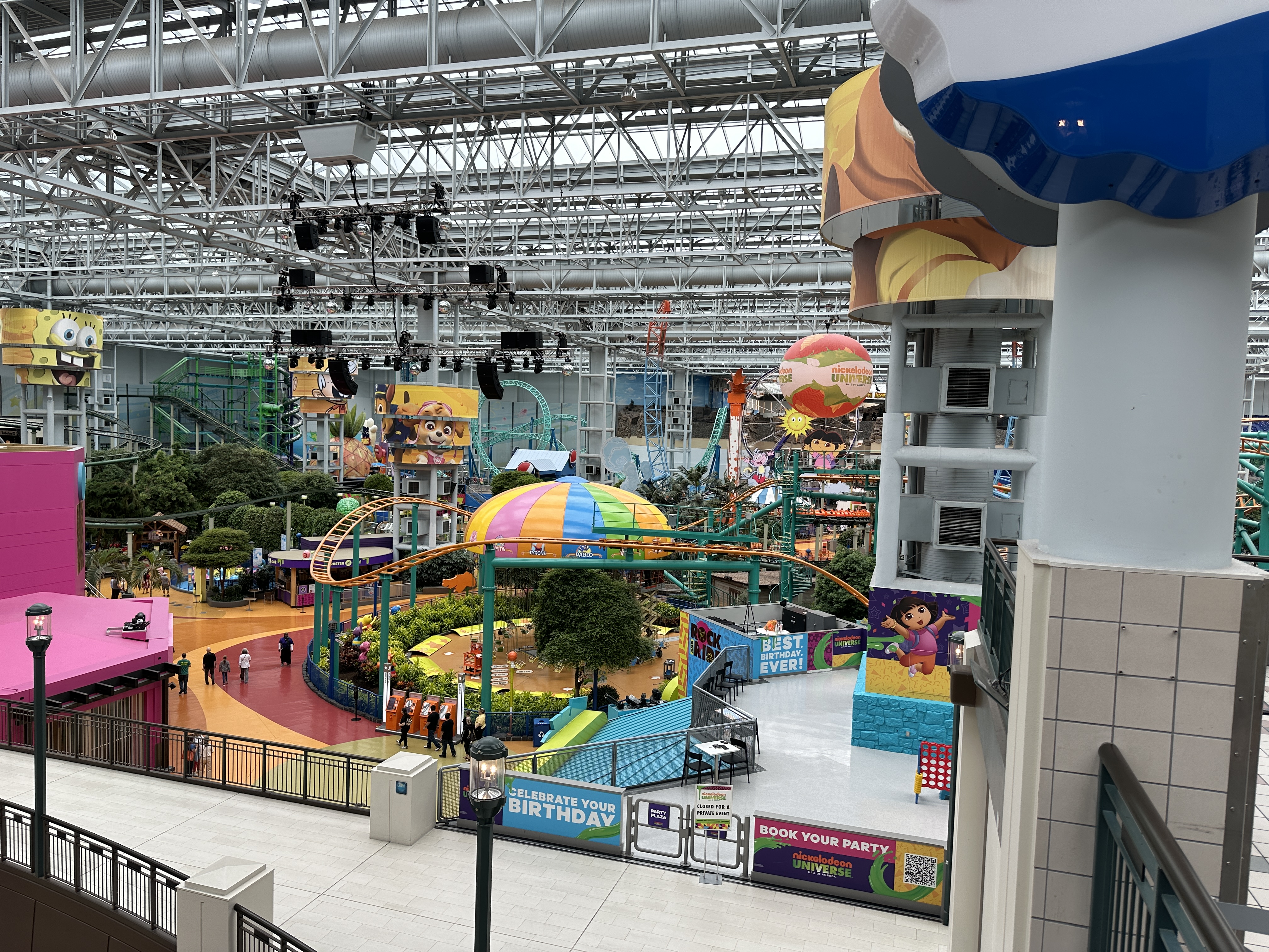
Nicholodeonland 
Knight and faithful steed 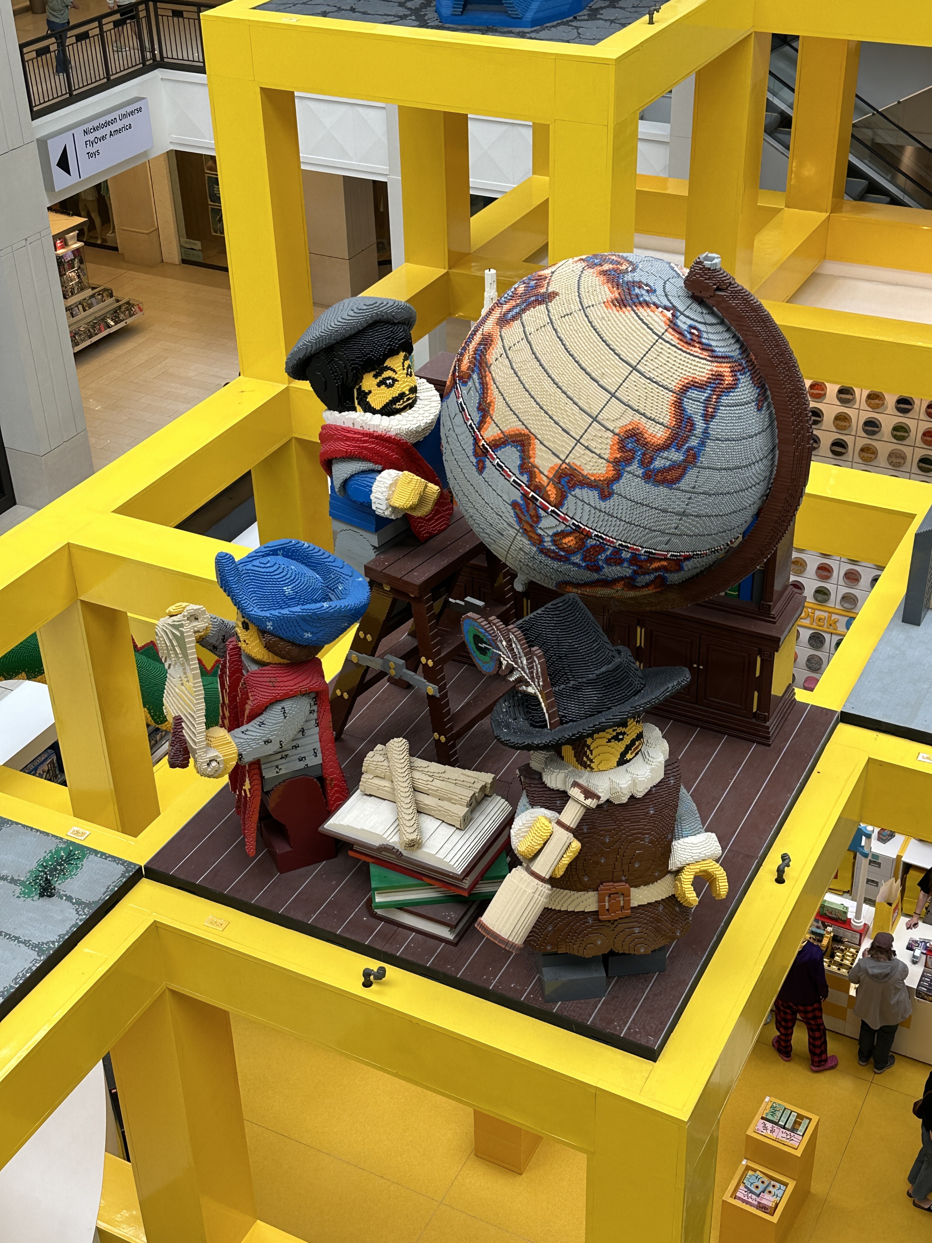
Columbus and crew 
Rescue Helicopter 
TMNT to the rescue 
A vertical drop on the rollercoaster
Our next bit of exploring took us to Fort Snelling, a
reconstruction of an early 19th-century fort above the confluence of
the rivers. The primary purpose of the Fort was to project American influence
over this part of the Louisiana Purchase to dissuade the British from getting
too comfortable trading with the Dakota. The Fort was more of a strategic
political base than a military bastion. Zebulon Pike, one of the first Americans
in the area, took it upon himself to negotiate a treaty with the Dakota.
Unfortunately, he had no authority to do so, and the treaty languished in
Congress for over a decade before it was finally ratified long after it had
lost any impact. The closest supply point for the Fort was St. Louis, a
six-week journey away. Therefore, the Fort became self-contained and provided a
base for people moving into the area. 
Historic Fort Snellings
In the 1830s, a military officer
brought his family and an enslaved person named Dred Scott to serve at the
Fort. Mr. Scott married another enslaved person, and they served in the Hospital
Kitchen. At the same time, their owner received wages for their service. Dred
and Harriet Scott petitioned for their freedom when the owner died, a common
practice. They fought the legal challenges, even after their new owners moved
them to Missouri. After over a decade, the Supreme Court ruled against them,
declaring that they were neither citizens of the US nor able to sue for their
freedom. This ruling became a significant reason the North became more
committed to ending slavery and fueling the fires that led to the Civil War. 
Dred and Harriet Scott
Meanwhile, the Dakota wanted to work with their new neighbors, but the friction built up as settlers claimed more and more land. Promise after promise was made and broken by the US Government. In the 1860s, during the Civil War, the Dakota staged an uprising, and the Federal Troops took over the Dakota lands. Many of the Dakota were shut up in a concentration camp at the Fort before being forcibly relocated to the Dakotas.
Over the next 80 years, Fort Snelling developed into a major military installation growing far beyond their perch over the confluence. Here are a few pictures from our afternoon at the Fort.

The Defensive Roundhouse complete with protest tags 
The old barracks 
Parade Ground

 |
| The Suttler |
 |
| merchandise for enlisted and officers alike |

 |
| The Schoolhouse next to the Magazine where the gunpowder was stored. |
 |
| The Magazine |
 |
| Accomodations in the early 20th century. |
 |
| Early accomodations for 12 soldiers |

 |
| The Hospital Kitchen where Dred and Harriet Scott lived |

 |
| Site of ancient stone workers from 9,000 years ago. |
 |
| The Magazine Interior |
 |
| The Roundhouse, Oldest of the buildings at the fort. |
 |
| level one |
 |
| level two |
 |
| Upper Level |
 |
| Marlene made it to the top! |
After a stop for some Ethiopian food in St Paul, we headed
to Minnehaha Falls. The area in and around the Twin Cities is composed of a
brittle crust over softer rock. Like the Mississippi River, Minnehaha Creek has
eroded the layers beneath the falls and has worked its way back several miles
from where it began at the end of the glacial period. Today, it sits in the
center of Minnehaha Regional Park, which includes other features like the
"Song of Hiawatha Garden", Longfellow Gardens, and the Statue of
Hiawatha. The falls themselves are much larger than I expected. We could only
explore a little of the park because the stairs to the trail along the creek
were very long and steep. Here are a few shots from the park well above the
Minnehaha Creek.
Minnehaha Falls


 |
| The "Song of Hiawatha Garden" |
As wanderers, we enjoy our zigs and zags. And this zig has just begun. We have a few more days here in Savage before heading south to Rochester, where we hope to visit the Mayo Clinic museum. Then, we are back on the road to The Wisconsin Dells for a week. I'm not sure what we will see, but with health, weather, and time allowing, we will wander around enough to make this zig worthwhile. I'm glad you are along for the ride.
Travel well, my friends!
Bob
Note about pictures. FB has made it increasingly difficult to post photos from our travels. It is very frustrating to spend 30 minutes selecting and adding captions to pictures only to have FB freeze up and not be able to post them. I will keep trying from time to time, but I will always upload my shots to my Flickr account (https://www.flickr.com/photos/bobdees/). I will continue to share many of my favorite pictures here on the blog, along with commentary and descriptions that I hope prove helpful and entertaining. In short, I cannot rely on FB, and I suggest you subscribe to the blog or check Flickr regularly to see the pictures from our travels. If you want to share them with others, send them a link to the blog (https:/bobswanderlusting.blogspot.com/)or my Flickr account. Again, thanks for following along.
RLD


No comments:
Post a Comment